41

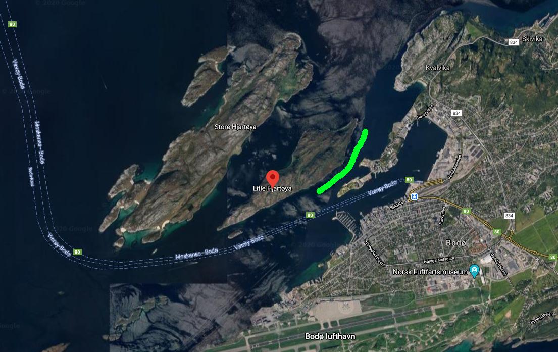
I would like to get to this island, marked by a red marker (on Google Maps):

map of Bodø city and surrounding islands

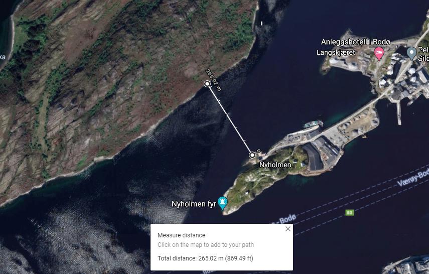
The obvious route would be to swim across the strait marked by the green stripe. Distance is not that big, ~270m, I can swim that much.

close up map of strait

(I know there is a shorter distance between Langskjæret and the island, though I cannot go to Langskjæret, as it is a construction site, so entry is forbidden.)

Issues

  • Would it be legal or the coast guard or something similar would intervene?
  • Big ships often use that corridor, I have observed them. Will they notice me?

Question

Can I swim there without taking unreasonable risk or breaking Norwegian law (or other rules I am supposed to follow)?


Update: thanks for everyone who has contributed. Based on the answers & my love for my life, I will not swim there.

9
  • 17
    Regarding the safety of swimming in a shipping channel, you may get better answers at outdoors.stackexchange.com. Commented Aug 23, 2020 at 22:15
  • 37
    It is not illegal, but you should not underestimate currents along the Norwegian coast (I have no knowledge about this strait though) and you can not expect ships to take notice of you. Have you considered renting a canoe or kayak? There seems to be plenty of options for that in Bodø. Commented Aug 23, 2020 at 22:33
  • 6
    I think you should go for it BUT, as with any "channel swim" you of course need spotters in a boat to go with you. I bet you could find a local with a dingy with an outboard, who'd be up for an adventure like this. (The idea of "just hopping in" and swimming a shipping channel is of course impossible.)
    – Fattie
    Commented Aug 24, 2020 at 13:28
  • 4
    What Fattie said. You can't swim out of the way of commercial cargo ships traveling at 15 knots, let alone high speed ferries etc. FWIW, one of my relatives worked for more than 30 years as captain of a sail training ship. In that time, he only had one fatality among the volunteer crew. That was a teenager who decided to jump overboard and swim 100 yards to the shore "just for a laugh," and got his friends to create a diversion so he wasn't immediately reported missing.
    – alephzero
    Commented Aug 24, 2020 at 14:59
  • 6
    While the direction of "your" channel may make it relatively less subject to strong currents compared to its surroundings, you are aware that this part of the Norwegian coast is famous for its strong tidal currents? Your proposed crossing is maybe 5 km from the mouth of the Saltfjord (yes, the one with the en.wikipedia.org/wiki/Saltstraumen somewhat further in).
    – cbeleites
    Commented Aug 24, 2020 at 23:24

6 Answers 6

88

This looks to be a somewhat foolhardy idea. Aside from the legality (Tor-Einar Jarnbjo thinks it's legal) there are some practical considerations:

  • The point you've marked appears to be at one end of a working port and is quite possibly privately owned. A look around on Street View shows that that area is monitored by CCTV, so you're likely to be interrupted by security.
  • The water's edge is actually a quay several metres above the water. You might be happy to jump down but how will you climb back up?
  • 270m is a narrow channel for ships. Even if they see you there's likely not much they can do to avoid you.
  • Currents - narrow channels are notorious for them. Tidal currents can reach several knots - you'd need to check this specific location. You might make it across at slack tide, but then it's a six hour wait to return.
  • Water temperature - that island is above the Arctic Circle. The water will be cold. If you're unprotected, cold water can kill you in minutes.

My thoughts: If you really need to visit a small rocky uninhabited island just off the Norwegian coast, take a boat.

7
  • 21
    Excellent answer, with a tiny objection on the part about the water temperature and killing within minutes. I understand this as a general hint towards untrained people being careful. However, I regularly swim in those temperatures and conditions, completely unprotected for up to 60 mins, depending on my level of training. I apply Wim Hof's (wimhofmethod.com) breathing technique and occasionally swim in high altitude lakes in Switzerland and channels in Norway. It's important to be able to read tides and currents, be prepared and always have someone with you on a boat or a kayak.
    – ikaerom
    Commented Aug 24, 2020 at 8:51
  • 11
    I must second the objection against water temperature. The Gulf Stream keeps the water relatively warm and leisure swimming/bathing in the ocean is perhaps surprisingly common in northern Norway. A camping site nearby reports right now a water temperature of 13°C. which is nothing to be overly concerned about. Commented Aug 24, 2020 at 9:12
  • 14
    @Tor-EinarJarnbjo: Might not be nothing to be "overly concerned about" but without the benefit of running from a sauna, I'd consider anything below 16° far too cold for more than a five-second dip. Overall, it's a good note because the OP doesn't say where's they're used to swimming.
    – gktscrk
    Commented Aug 24, 2020 at 11:55
  • 14
    @SolomonSlow None of the points I made are insurmountable. Yes, one can arrange access, start from a different point, check tides, arrange an accompanying boat, etc., all for a not particularly interesting swim. But just showing up and jumping in the water has a number of risks, (some of which are potentially fatal,) in a way that swimming in a pool or off a popular beach does not.
    – user105640
    Commented Aug 24, 2020 at 20:10
  • 4
    Finally, water near ports can be really filthy. Commented Aug 25, 2020 at 10:39
40

Having worked as a boat pilot for a dive center, I have to agree with @Arthur's Pass answer. You must understand that is is really hard to spot someone swimming in the water, you will be hidden behind any small wave. Also, the bigger the boat, the less the pilot looks out for things like swimmers, especially in an area where there is usually no swimmers.

Again, as said Arthur, the might not be able to avoid you. The bigger the ship, the harder it is to maneuver precisely.

I have to strongly recommend you not to take that swim. Remember boats have propellers under their hull that can shred you down to pieces.

38

Just chiming in as a local that the area is frequented by not just ships with professional equipment and captained by professionals but also by many locals out for a quick fishing trip, leisurely drive, or, in rare cases, quick trips using small fast craft. These are unlikely to notice a single swimmer with no marker.

(As an aside, the sides of Litle Hjartøya are in many places too steep to get out of the water without climbing. I can't recall this exact area, but I believe most of that side of the island is sheer rock.)

A much more sensible option would be to rent a small boat in Bodø, or to charter someone to take you there and back again. If you have some time you could advertise in the regional newspaper, or if you are in the region I would simply ask around the harbour.

If you're instead looking for a swimming challenge there are plenty of beautiful areas with or without small islands in the vicinity:

  • Mjelle, a popular swimming and leisure spot.
  • Sørfjorden in Mistfjorden, part of the new Sjunkhatten national park.
  • Vatnvatnet, except for the north-eastern arm marked "Heggmoen skytefelt", an army training ground.

Another option would be to take the "hurtigbåten" to any of several islands nearby.

4
  • Good suggestions, but do you think there's actually any water in vatnvatnet? I have my doubts... Commented Aug 26, 2020 at 13:23
  • @leftaroundabout Is that a joke? Otherwise I don't know what you mean; there was a few million cubic metres (aka. unchanged the last three decades) last I was there.
    – l0b0
    Commented Aug 27, 2020 at 7:03
  • @l0b0 The name is literally "waterwater" which due to the norwegian word for lake being the same as "water" would dub it "the waterlake" . Seems someone was surprised a lake had water, enough to name it so.
    – Stian
    Commented Sep 24, 2020 at 13:41
  • @StianYttervik I believe the reason for the name (this is going way back into childhood memory) is that it's a "double lake", connected only by a tiny gap at approximately the middle.
    – l0b0
    Commented Sep 24, 2020 at 20:36
23

I cannot answer all points for you, but as I kayak frequently on bodies of water used by ships (also sometimes in narrow ship channels or in places like the Lorelei), here are some points to think about. They stay the same for both swimmers and small boats, so they are relevant even if you decide to rent a kayak or canoe. And one specifically for swimmers: due to the way the water moves, you will spend more energy to cover the same distance in running water than in a pool, reducing your effective radius.

Ships

It is certain that they will not see you. A cargo ship of the river type is huge, an ocean going one is humungous. The first deck is several stories above the water, the captain's booth is at the highest point far in the back, and the ship body spans a long distance before the booth. This means that, when the captain looks out of the booth, he cannot see anything a few hundred meters in front of the ship, because it is in the ship's own "shadow".
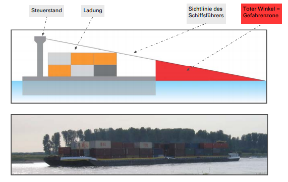
"sight shadow" of a ship

For river ships, this "shadow" is several hundred meters long. You are hidden from view long before your head becomes large enough to be seen.

But the even bigger problem: avoiding being hurt by a ship is very different from avoiding being hurt by a car. One danger is being run over - this is almost impossible for a single-unit ship, but apparently can happen with a tug-and-barge combination. With the "standard" ship, what happens is that you pass it at what you thought is a safe distance - and then you get sucked by its stern current and into the house-sized propellers. If you avoid this, you can get caught in the waves following the ship - it can happen that a 1000 ton wave throws you right onto a spur dyke (I've heard that this causes several injuries each year on the Rhine).

Sport boats

I don't know what it is like in the area there, but note that small "fun" boats might be worse than the very large ships. The size of the waves depends not on the size of the boat, it depends on its speed - if you get passed by a 60 kmh boat (and if it is loaded with boys showing off to shrieking girls, you can only hope it will pass you) you will be bobbing on some high waves long after it's gone.

Port area

Somebody wrote that this area is a port. Around a port entrance, you have two currents meeting, and there are many structures built underwater. This creates quite weird currents right where you wouldn't expect them, and makes it very dangerous to enter the port as a swimmer. I have seen newbies in kayaks capsize in smaller currents.

Also, it might be that even where swimming in a given body of water is legal, swimming through a port entrance is illegal, so make sure if there are ordinances about that. Also, you might go there and see a large sign telling you that the port is private and only allows entry of ships scheduled to land there - in that case, technically even entering with a kayak will be an offense.

Water temperature

As mentioned in other answers, it is an important thing to consider. Somebody commented that people can train to spend time in very cold water, but without such training, hypothermia is a very real risk. The safety rule I have been taught is:

If you fall into water below 15 C, you have about as many minutes as the temperature until you become incapacitated.

"Incapacitated" here means that you won't be able to move in a coordinated fashion and will need a rescuer even for something as easy as climbing onto a boat or raft. If you read German, you can see details here.

So take care, either as a swimmer or as a paddler - if you have never paddled before and cannot read currents and/or have never passed ships, take an experienced buddy with you.

19

In downtown Bodø, a couple of hundred meters away from your planned swim, is Bodø Radio, one of the headquarters of the Maritime Radio (contact page).

They may be able to assist you in several ways:

  1. They have the ability to reach out to boats in the area, warning boats about the presence of a swimmer in the strait. This is the way of coordinating things with ship traffic, as everyone with a ship radio has "lytteplikt" (duty to listen). Announcements of unusual conditions relevant to ship traffic is routine.

  2. They may be able to tell you exactly why this is a bad idea, with more certainty than you are likely to find on some internet forum.

Not sure they will be thrilled about this project, but they will definitely like to be told in the case were you decide to go ahead with the idea anyway.

19

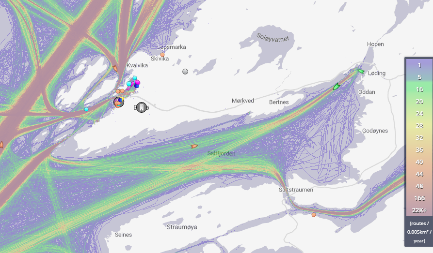
To add to the "bad idea" suggestions, I looked up the traffic density on marinetraffic.com and got this result (unfortunately the highest zoom at which it draws the density maps):

Shipping density map

Converting the units of the red areas to ships per 0.005 sq km per hour (crudely dividing by hours in a year) gives about 2.5 ships per 70 x 70 metre square per hour, which will be an underestimate for multiple reasons: small boats used by locals aren't counted, and presumably you'll be doing this during daylight and the ship density will be higher then.

It's probably too far away to be relevant, but note that the airport there shares facilities with an active military airbase, so the authorities might be a little more stringent on people doing relatively unusual things to get places which people don't usually go.

3
  • 1
    That is indeed too far away from the airport to be relevant - you'd have to swim several many times further across much more heavily trafficked areas to get to the airbase. That's not to say you wouldn't have an audience in any case.
    – l0b0
    Commented Aug 24, 2020 at 19:30
  • I have no idea how to read the map, which is so small that I can't recognize any colours in the strait, but I have no idea how you manage to change 0.005 km² to 70 m² when it actually is 5000 m². I did however have the map up and running for a couple of hours earlier today and during that period, only a single fishing vessel vent through the strait. I know it looks as if most northbound traffic to and from the harbour in Bodø goes through that strait, but the harbor is not very big and might not have very much traffic at all. Commented Aug 25, 2020 at 22:36
  • @Tor-EinarJarnbjo I meant a square with sides 70 metres long, edited to make that clearer. Like I said, that's the biggest resolution it will draw that map, and I'm assuming the traffic which enters the strait at the north leaves it at the south (which may be a bad assumption due to the locations of the docks). I am thinking now that it does a pretty bad job of dealing with the top end of the density scale, showing 166 and 22,000 as basically the same
    – llama
    Commented Aug 26, 2020 at 3:48

You must log in to answer this question.

Not the answer you're looking for? Browse other questions tagged .