24

I occasionally need to drive into Germany for work and since I'm usually taking a rental car it can be troublesome to obtain an Umweltzone sticker while on the road. Therefore it is useful to know where exactly do all the Umweltzones begin and end.

Is there a comprehensive official map of all the German environmental zones? There are websites which list the cities where the Umweltzone sticker is mandatory, but their maps are not detailed enough to see the exact border of each zone.

12
  • 6
    I never realized how hard it is for tourists to get this bit of information ahead of time....
    – Layna
    Commented Jun 12, 2017 at 12:59
  • 6
    @Layna many tourists don't even know the environmental zones exist in the first place...
    – JonathanReez
    Commented Jun 12, 2017 at 13:33
  • 6
    I would be surprised if rental cars don't already have the sticker - unless you're picking up the car outside of Germany. Rental cars are usually less than 6 months old and ought to conform to the highest emission standards. e.g. Hertz "Alle Hertz Mietwagen aus Deutschland und der Schweiz sind mit einer solchen Plakette ausgerüstet"
    – paul
    Commented Jun 12, 2017 at 13:48
  • 1
    @paul German rentals are ok now (but were also a problem in the first 2-3 years of the zones). If you are Dutch and need go to Germany for work in a company car or company mandated rental you are screwed. I saw a Belgian colleague have his car impounded in Stuttgart for lack of the sticker a few years ago. Cost him about €700 to get it back. (The fine, admin cost and towing fee together.)
    – Tonny
    Commented Jun 13, 2017 at 5:19
  • 2
    @paul What do you need to do to get a car impounded for the missing sticker? I was driving around for a few years without getting noticed. The fine is about 40€ which I also had to pay eventually, there might be additional administration cost if it is a foreign car. Also there was an additional "fee" of a point in Flensburg which had been removed with the last reformation of the penalties a few years ago.
    – kap
    Commented Jun 13, 2017 at 13:12

6 Answers 6

11

Here is a map provided by the responsible German authority, the Umweltbundesamt.

If you are hiring a car in Germany and would like to know more, the car rental company will advise you further, either during the reservation procedure or upon arrival.

4
  • Thanks. That map tells me all I need to know, on my planned journey I will not visit any of the Umweltzones.
    – Willeke
    Commented Jun 12, 2017 at 17:34
  • 1
    Would any car rented in Germany has no Umweltplakette in first line? Commented Jun 12, 2017 at 19:00
  • @DanubianSailor Very unlikely. Rented cars are usually pretty new and all new cars usually have a green Umweltplakette (i.e. the currently "best" one).
    – scai
    Commented Jun 13, 2017 at 8:25
  • This map seems great, but you can only zoom in to a certain level. Any way to increase this limit? Commented Jun 13, 2017 at 8:58
19

The most official source is the Umweltbundesamt (UBA), the Federal Environment Agency. You can use the GIS website of the UBA, which provides nice PDFs of each Umweltzone. Example: Berlin (Euro 3). There's a map of Germany as a whole as well.

A less official site, but with a much broader approach, is Urban Access Regulations, which collects more classes of restrictions in one place, but with a slightly harder to use interface and a much slower site. Example: Berlin. It also links detail maps, if provided by the municipality (example: Berlin).

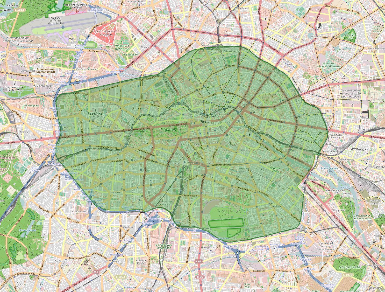
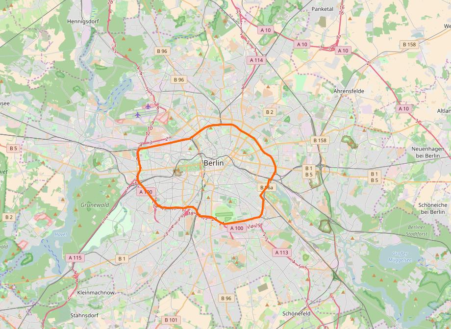
My first idea was to use OpenStreetMap, which also has a layer for the Umweltzonen, but the layer's proposal hasn't left the Draft status, so I wouldn't expect it to be complete. Nonetheless, the tag appears on quite a lot of cities all over Europe, so you might give it a try, starting here (beware the Status column!) and clicking the number in the Link column to find the OSM detail map. (Example: Berlin.)

OSM-Karte der Berliner Umweltzone, Lizenz: (ODbL), (CC BY-SA) OpenStreetMap-Mitwirkende

4
  • 3
    Regarding OSM (and slightly offtopic): It is not really relevant whether the tagging proposal left the draft status. Relevant is the actual usage of the tagging scheme. Also, an accepted proposal doesn't automagically make the data appear in the database if there are no good sources available. Either way, +1 for mentioning and showing OSM! :)
    – scai
    Commented Jun 13, 2017 at 7:57
  • GIS website is the way to go. When stopped by the the police in an Umweltzone without a sticker, referring to a user-made google map layer or OSM won't help much. Commented Jun 13, 2017 at 9:24
  • @scai thanks for clearing up the normative power of such a draft :) I was just happy that some of the zones had been created despite the status of it :) Commented Jun 13, 2017 at 10:01
  • @DmitryGrigoryev I bet you even can't argue with an official map either. It can be incorrect or outdated. The signs on the ground matter, nothing else.
    – scai
    Commented Jun 13, 2017 at 10:44
10

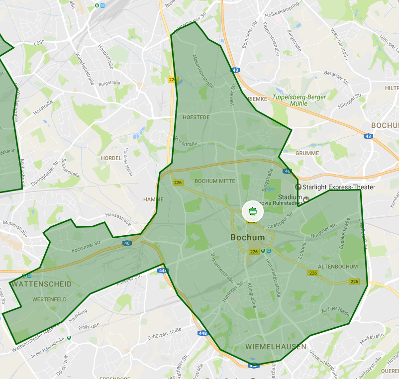
There is a user-made Google map with a clickable list of cities. It would seem that the borders of the Umwelt zones are clearly defined. For example, below is a screenshot of the zone in Bochum:

Bochum umweltzone map

3
  • Unfortunately, not all zones are defined in this map. Many cities are marked with the green sign but the zone itself is not outlined. F.e. Herne and Recklinghausen (both to the north of Bochum).
    – Neusser
    Commented Jun 12, 2017 at 15:10
  • 1
    How accurate/reliable are those informations? For example, in Baden-Wurtenberg the whole exits on Autobahn are marked as 'Fahrverbot ohne Umweltplakette' which suggests, everything behind that exit is Umweltzone... Commented Jun 12, 2017 at 19:00
  • @DanubianSailor: I'm not sure what you're seeing, might be a browser playing up. Unlike the Ruhrgebiet, Baden-Wurtenberg has only zones near the main cities. Stuttgart has a quite large area, being a big town with suburbs. Yes, the Autobahn exits of the A831 basically put you straight inside the Umweltzone.
    – MSalters
    Commented Jun 12, 2017 at 22:44
6

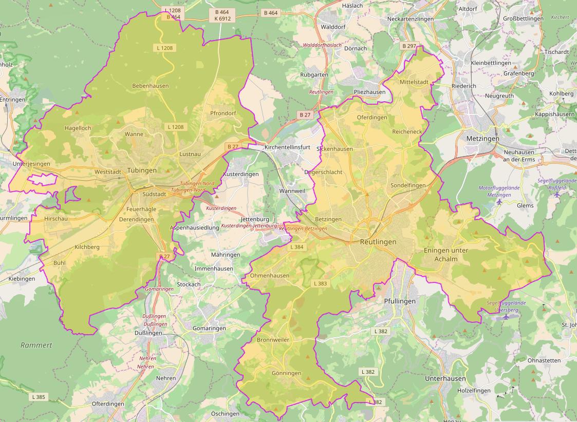
I just found this site that offers zoomable maps for all(?) German environmental zones (need to scroll down to get to the Germany section): https://www.green-zones.eu/en/green-zones-app/zones-overview.html

You can enlarge each map by clicking the thumbnail on the top left corner on a subpage.

enter image description here

4

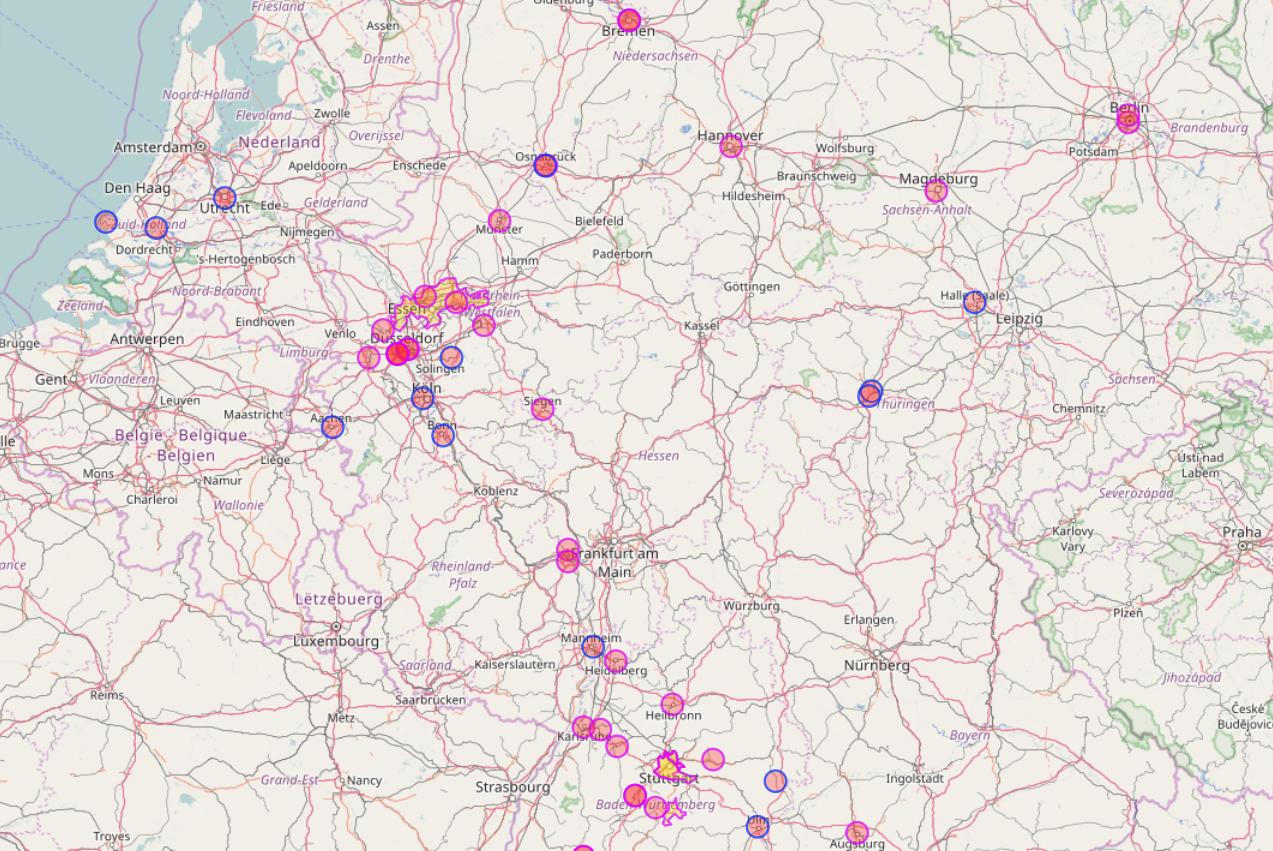
User hiergiltdiestfu already mentioned in his answer that OpenStreetMap (OSM) also contains so-called low emission zones (LEZ) which represent environmental zones. While there seems to be no OSM-based map showing these zones you can use Overpass API and overpass turbo to create such a map on the fly:

http://overpass-turbo.eu/s/pI8 (the query will take quite a while to run)

[out:json][timeout:600];
(
  way["boundary"="low_emission_zone"]({{bbox}});
  relation["boundary"="low_emission_zone"]({{bbox}});
);
out body;
>;
out skel qt;

low emission zones on OSM

low emission zones on OSM

Note that the query will take some time to complete for large areas. Also the map will be incomplete since not all low emission zones have been added to OSM yet.

1

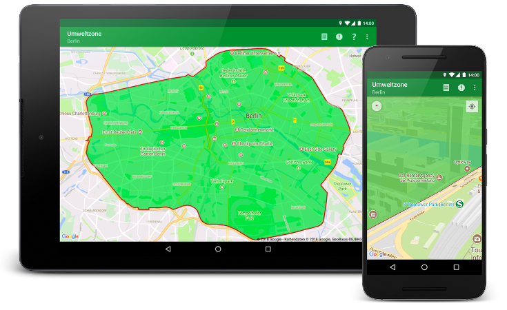
You can eventually use the Umweltzone app for Android which I develop as an open source project since some years.

App screenshots

The app works both on tablets and smartphones.

You must log in to answer this question.

Not the answer you're looking for? Browse other questions tagged .