19

I have ~18 days to hike across Iceland during August. I'm a good hiker (last summer I spent 40 days across the Alps) and I'll be alone. I'm looking for advice for my itinerary (southbound).

I'll have a GPS and I looooove going off-road (wilder == better), but with the glaciers and the rivers I can't go without preparing my route well. If possible, I'd like to avoid the most dangerous rivers (wide or with strong stream).

For the northern part, I'll probably follow this track (Asbyrgi - Nyidalur).

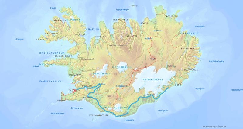
Then I'd love to go see the Kerlingarfjoll massif (so hiking in the south of the Hofsjökull glacier), then going south to Sveinsgil and Landmannalaugar. Finally, I could follow the Landmannalaugar trek to go to the coast.

With a map: enter image description here In red the part I'm not sure if feasible

But I don't know if it's possible (not too dangerous) to do Nyidalur - Kerlingarfjoll - Landmannalaugar. Is it the case?

Are there some detours I should take? And finally, is this globally a good itinerary?

4
  • 2
    See also The Great Outdoors.
    – gerrit
    Commented Jul 5, 2016 at 13:15
  • Coooooool ! so cool
    – Fattie
    Commented Jul 5, 2016 at 14:08
  • Hey what's the distance in KM ?
    – Fattie
    Commented Jul 5, 2016 at 14:15
  • @JoeBlow I plotted a very crude approximation using five straight lines on the distance measuring tool on Google maps. It looks like somewhere in the region of 400-450km. Commented Jul 5, 2016 at 17:37

2 Answers 2

17

Your planned itinerary is too ambitious for a hiker not experienced with Iceland. It might be fine, but might is not enough. Considering the uncertainty of hiking off-trail in unknown terrain, you need to have a plan that allows shortening/escaping if your route fails.

Some things that are different in Iceland compared to other parts of Europe:

  • Too much water. Even tracks cross rivers that, after rain or heavy snowmelt, might be too dangerous to cross. Some rivers are very wide and the water level in rivers might rise so quickly that you could find yourself stuck on an island. There are big river crossings between Þjórsarver and Nýidalur, which are included in your itinerary. It might work. Or not.
  • Too little water. Yes, even in the same area. The interior of Iceland is a desert. Your route passes through Sprengisandur. The verb sprengja means to ride a horse to death. People used to take detours of hundreds of kms to avoid this area. Your route also passes between Nýidalur and Asjka; in this area, there is no drinking water for 50 km. The only water you pass might be too silty to drink. You can handle this if you come prepared, but it might kill you if you treat it like Norway and you don't come prepared for a desert.
  • Wind. In Sweden, they think 20 m/s is really windy. In Iceland, you might get 50 m/s wind gusts. Good luck surviving that.

Having said that, the southern part of your route is relatively easy, as it follows Fimmvörðuháls and Laugavegur, which are popular, very busy hiking routes. You can easily hike those on your own, as you're never far from other people and thus rescue. But when you're off the beaten track in Iceland, you should know what you're doing. I've hiked in Iceland, the Alps, northern Scandinavia, the Canadian Rockies, the Ural Mountains, and elsewhere. In Iceland I've hiked at Lónsöræfi as well as around Hofsjöküll, passing through Þjórsárver. A trail on an Icelandic topographic map is not always a trail; it might just be a route, which might mean no more than a cairn every couple of km, if at all. A route may cross deep, wild rivers and may require scrambling along steep scree with raging rivers below. I've tried to follow routes marked on Icelandic maps and found the terrain completely unpassable. In a total of around 20 days of Icelandic hiking, I met exactly one other hiker. Such lonesome terrain one rarely sees even in remote off-trail hiking in Swedish Lapland.

Considering that Iceland is very different from the Alps or Scandinavia and you are not experienced with it, you should choose an itinerary that is less ambitious and more flexible. I expect some parts of Iceland are easier than Lónsöræfi, and if you hike on fjallvegur you can make more distance, of course. So maybe you can do it, but maybe is not good enough. Choose an itinerary you can shorten or lengthen based on your progress, get familiar with the landscape, and then decide if you can attempt the coast-to-coast hike another year.
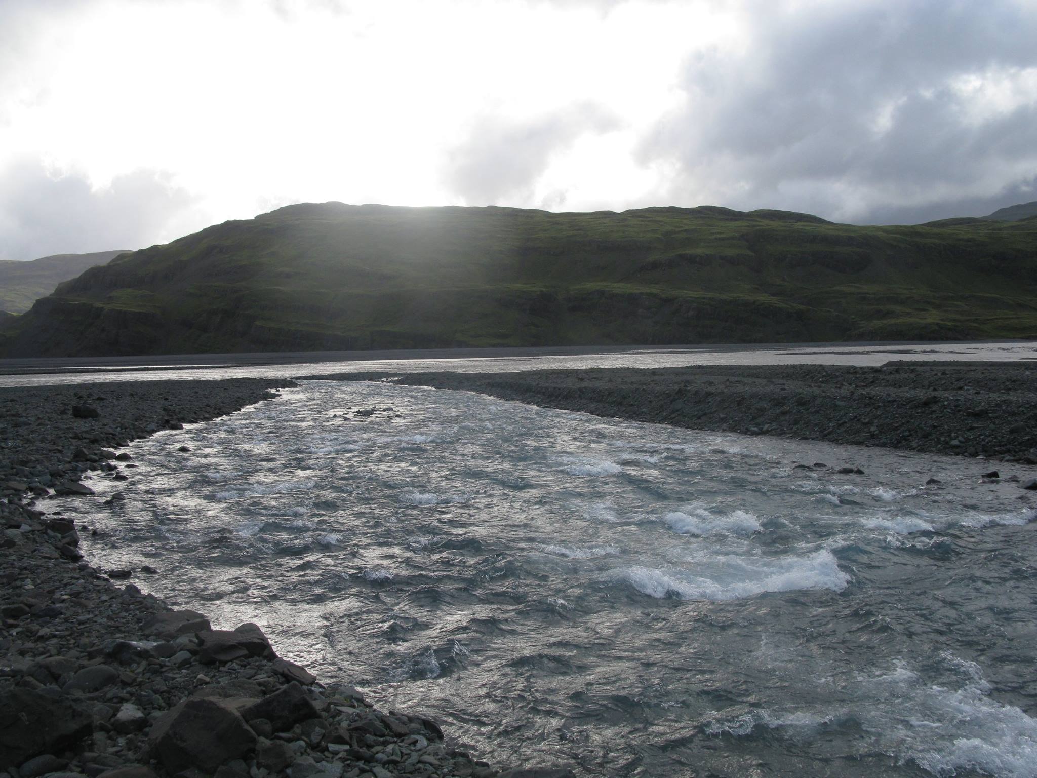
Hnappadalsá in Lónsöræfi
Hnappadalsá in Lónsöræfi, 20 September 2015. This river was hard to cross, and would have been out of the question without my wading staff.

See also advice on Outdoors SE for rivers.

In any case, whatever you do, DO NOT SET OFF WITHOUT A SATELLITE PHONE/PAGER or at least a PLB. A satellite pager or satellite phone is the better alternative, because you can receive weather forecasts, which can be life-savers. You don't want to be stuck in the Icelandic highlands in a snowstorm.

15
  • 1
    @Shan-x Me too, however river-crossings are risky and time-consuming. You don't want to meet a river you can't cross 14 days into your trek. Finding a mountain road is not a guarantee either, for some mountain roads may be inaccessible to any kind of vehicle when crossed by a river too deep or fast. Let me find a photo of Hnappadalsa in Lónsöræfi that I had to cross. You can find my full Lonsöræfi album here.
    – gerrit
    Commented Jul 5, 2016 at 13:32
  • 2
    @Shan-x You can rent a satellite phone for £5/day. Three weeks will be £110. Not bad for something that will save your life if you are in trouble. If you can't afford it, rent a PLB; it's cheaper, but harder to find and less good for it only helps you if you activate it and you can't communicate.
    – gerrit
    Commented Jul 5, 2016 at 13:38
  • 1
    @Shan-x While not hiking I did spend a weekend in the back blocks of Bolivia and during that time rented a sat phone. The price was pretty reasonable and much cheaper than buying.
    – Peter M
    Commented Jul 5, 2016 at 13:38
  • 2
    @JoeBlow Even with four weeks available it is problematic — I don't think it's feasible to carry four weeks worth of food. Two weeks is fine, three weeks is pushing it. There's no form of habitation or opportunity to resupply in interior Iceland.
    – gerrit
    Commented Jul 5, 2016 at 14:13
  • 1
    @Shan-x I have answered. The Alps are mostly very easy to hike in, with trails, bridges, signposts, huts everywhere. If you do 30 km/day in the Alps, then 25 km/day in Iceland is overambitious. But if you are convinced of yourself, go ahead, but then I'm not sure why you're asking for advice.
    – gerrit
    Commented Jul 5, 2016 at 22:31
7

Warning, OP might have been lucky with the weather, do not assume that one successful hike means that you can do it as well.

I never answered my own question here. Having done the thru-hike accross Iceland, I guess that now I'm qualified to make a response. The answer from @gerrit was imho overly pessimistic, so here is its counterpart.

I hiked the red itinerary here:

enter image description here

Here is the GPX track. I made a few blog posts about it on my personnal website (french).

I hiked the 420km in 13 days, with the first 3 days much shorter (~25km/day max) and the 3 last around 25km/day (I was on the Laugavegur, so I was sleeping near the huts). In the middle, I went up to 50km/day, because hiking on the desert is quite easy as the sand was often compact. It was mostly off-road tracks, but I often went off-track for up to 2 days.

For someone used to hike in the Alps (or other mountains), hiking in Iceland is mostly easier because of the lesser elevation. My thru-hike had a total elevation of 7500m, corresponding to a 4 days hike in the Alps for me. The difficulties were very localised, but could be very tiresome (I remember crossing 2km of lava field in almost 2h).

The main hazards were:

  • weather: I had 2 days with winds up to 130km/h. I had a few hours with a fog so dense I couldn't see 10m ahead. Without GPS I would still be there.

  • river crossing: definitely the most dangerous. As I was alone, I had to really be sure before crossing. If a big river was ahead, I had to make sure to cross it the earlier in the morning possible, because the rivers are stronger the afternoon.

  • solitude: yeah, being all alone in the desert isn't so easy.

  • ground: some lava fields were very tiresome, difficult and dangerous (easy to hurt a leg). Other time, the sand wasn't compact so it was also tiresome.

The safety gear I took:

  • a satellite beacon to call for emergencies: I didn't use it (fortunaly). I could/should have use the Gen Spot 3 (can send beacon by e-mail to family and friends), but the mobile network wasn't so bad so it was ok.

  • a phone : as I said, I could send a message or make a call almost everyday, so it was sufficient.

  • a GPS : so handy. When the weather is good, you can probably (and I'm not even sure) do without, but when the clouds kick in, it would be foolish to be there without a GPS. I had a Garmin eTrex 20.

  • trekking poles: absolutely needed for river crossing.

  • a good (homemade) tent: there is no shelter from the wind in the desert...

That being said, if your are prepared enough (good physical condition, knowing how to use your gear), I think that hiking in Iceland is not so difficult. But it's not for everyone either :)

2
  • 1
    Great that you safely made it, but your final route is a bit easier than your original proposal. Crossing Þjórsa between Nýidalur and Þjórsarver is possible but hard according to notes I read at Þjórsarver; following F26 is of course much easier. Still, I think many people might not describe 50 km/day, including major river crossings, while carrying camping gear and 10+ days worth of food, as "easy". One question: How much water did you carry along on Gæsavatnaleið syðri, where it's 50 km to the next clean water — or did you somehow drink the silty water from Dyngjujökull?
    – gerrit
    Commented Feb 28, 2023 at 17:41
  • I'd say the actual route was several light years easier than the originally proposed one. One big difference (out of many) is the availability of a cell phone network... Commented Mar 1, 2023 at 13:32

You must log in to answer this question.

Not the answer you're looking for? Browse other questions tagged .