38

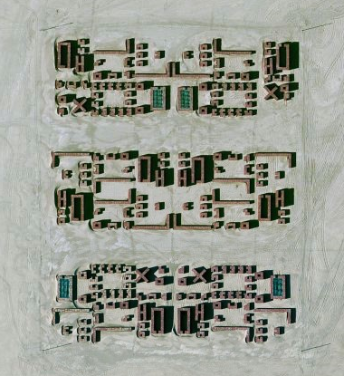
We were looking at this and trying to establish what it is and if it's something interesting to travel to. However it looks like some crop circle-style icons south east of it, and evidence of military nearby.

Can anyone identify what it is? Also seems to be tanks south of the structures?

Bing has higher resolution:

weird structure

1

2 Answers 2

42

Putting a screenshot of Bing Maps through reverse image search gives a second source (in addition to the forum) which includes some additional information.

From The Most Stunning Satelite Photos by the technology publication RumbleRum.

Fallon Range Training Complex, Dixie Valley, Nevada, USA

The Fallon Range Training Complex is a United States Navy military area spanning across 84,000 acres in the Dixie Valley of Nevada, USA. The complex primarily hosts air-to-air and air-to-ground training exercises. In the picture given below, you can see an installation of metal containers that are used for covert operations training as well as instrument recognition and calibration for spy planes and satellites.

You can read more about this complex on Wikipedia. That article also provides sources for the fact that this complex is in a restricted area. Therefore, even if someone would want to travel there, it would be illegal, very dangerous, and probably very difficult to attempt that.
9
  • 7
    Illegal, dangerous, difficult, and… stupid.
    – gerrit
    Commented Oct 21, 2016 at 10:36
  • 3
    +1, also light aircraft are restricted.
    – Gayot Fow
    Commented Oct 21, 2016 at 10:58
  • 6
    @Agent_L Great idea!! I'll try that on my next holiday and post a trip report as a Q&A here! I hope it won't be closed as off-topic... Now, considering they are actually shipping containers, how do I move them...? Hmmm... I think I'll need some sort of truck. Challenge accepted.
    – Fiksdal
    Commented Oct 21, 2016 at 13:46
  • 5
    It seems strange they describe it as Stunning! It's literally nothing more than a paint-ball field. So what?
    – Fattie
    Commented Oct 21, 2016 at 14:55
  • 7
    @JoeBlow: Just standard lazy clickbait wording... Commented Oct 21, 2016 at 18:13
20

From the discussion here, it seems that the structures are used for military "urban warfare" training and may be constructed from shipping containers.

Probably not the best place to visit while on vacation.

6
  • 1
    +1, I remember being told it was a military training ground. I had the impression it was for urban ground fighting, but targets will do nicely. Interesting discussion link also, thanks
    – Gayot Fow
    Commented Oct 21, 2016 at 4:34
  • 2
    Several comments in the linked thread do state that it's for urban warfare training rather than target practice -- which in my eye does look like the better explanation. The symmetric layout would mean you can pit two teams of trainees against each other and not need to figure out if one of them has a natural advantage of terrain you need to correct for when scoring. Commented Oct 21, 2016 at 7:36
  • 1
    Dutch version: google.nl/maps/@53.3860852,6.2627522,853m/data=!3m1!1e3?hl=en Commented Oct 21, 2016 at 7:57
  • 1
    AFAIK -> nato training grounds for the yearly nato ground operations. there's similar ones in zgza.
    – CptEric
    Commented Oct 21, 2016 at 8:07
  • 1
    @RemcoGerlich haha, "oefendorp" ... Exercise/practice town.
    – user30833
    Commented Oct 21, 2016 at 8:07

You must log in to answer this question.

Not the answer you're looking for? Browse other questions tagged .