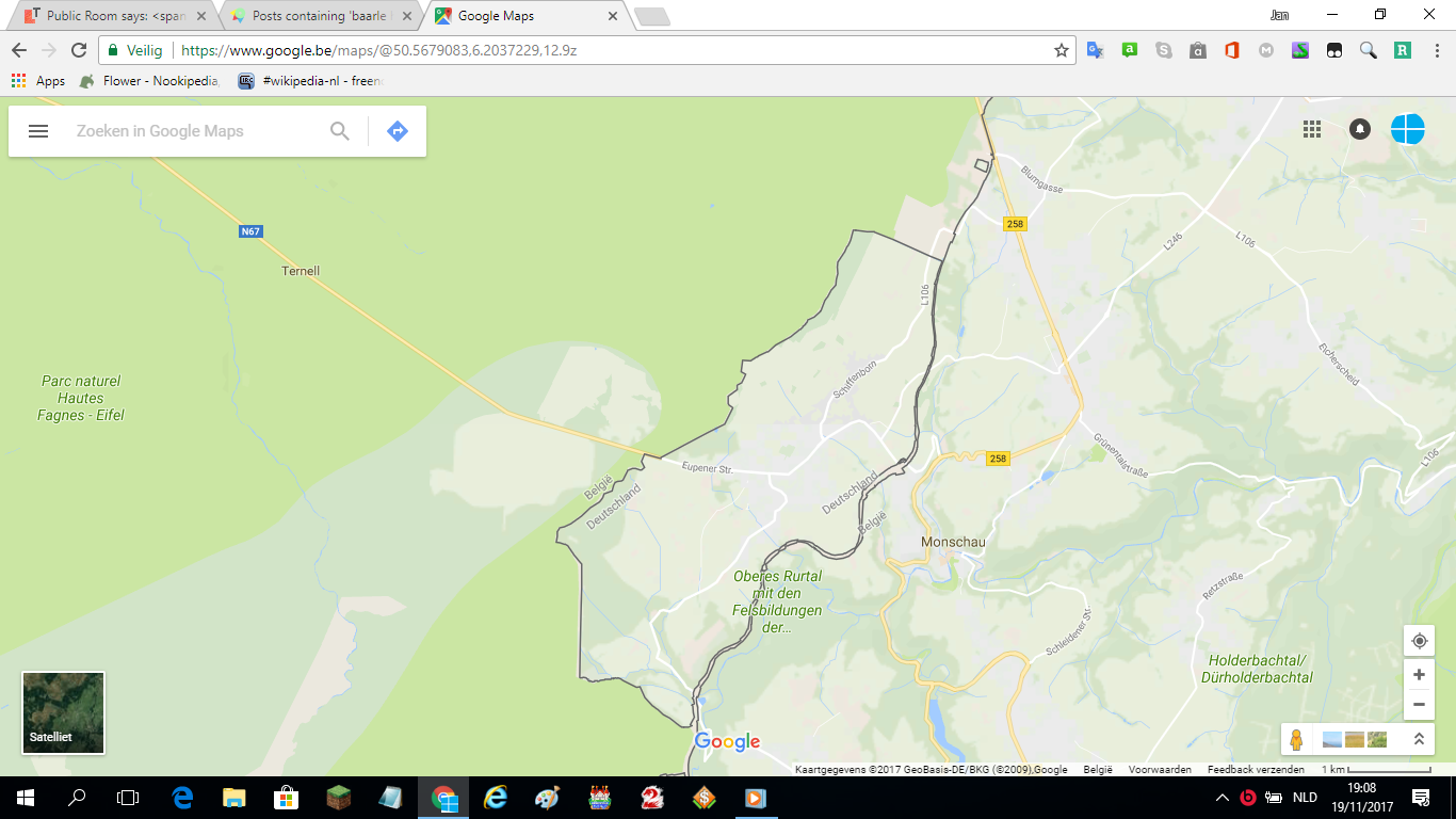
As you can see on the image above, Belgium and Germany have a weird border near the Oostkantons. It seems to be some kind of path east of the "real" border. Does anyone know more about this strange path and can you walk on it?
-
Well Willeke, it seems the area covers an even longer terrain than this, so I can't really zoom in. But I mean the small part, which is called the Vennbahn according to Johns-305's answer.– AutoDemolisherCommented Nov 19, 2017 at 19:03
-
24If you call this weird you haven't seen the town of Baarle-Nassau yet.– asdfexCommented Nov 20, 2017 at 11:00
-
4@asdfex You mean Baarle-Hertog?– AlexanderCommented Nov 20, 2017 at 11:04
-
5@Alexander: Depends on where you are. Baarle-Nassau is the name of the Dutch part. Baarle-Hertog is the Belgian name.– asdfexCommented Nov 20, 2017 at 12:14
-
2I'm surprised there isn't yet a tag for exclaves.– Golden CuyCommented Nov 21, 2017 at 1:55
2 Answers
The entire area and a good deal West of it used to be German territory at the beginning of the 20th century. In the late 19th century, a railway line was built from Aachen (much further north) to Luxembourg, the Vennbahn. Originally intended to transport coal and iron ore (in different directions) and to connect the area in between to the industrial centres, it was used strategically at the beginning of World War I to transport troops to attack Liège.
Following the Treaty of Versailles, the western half of this area was ceded to Belgium, creating the outermost border line you see on the picture. The Vennbahn would now cross from German to Belgian territory and back multiple times. Belgium argued that the line was of strategic importance (it had been used to prepare the attack on Liège, see above), so as part of the treaty the entire railway line (but only the railway line) from Walheim (near Aachen) to just before Wilwerdingen (in Luxembourg) became Belgian territory.
This led to the creation of multiple exclaves of Germany in Belgium. One was returned in the 1950s after that part of the railway became disused; five survive to the present day.
Nowadays, none of the tracks remain and the line has been refurbished as a cycle path in those areas where German exclaves were created. However, the foreign ministers of Belgium and Germany have confirmed that no renegotiations of the border shall take place so the situation will continue. (The original treaty did not contain provisions in case the tracks were disused — but the railway’s right of way still exists.)
Anecdotally, some residents whose houses and properties are too close to what used to be the railway line have both German and Belgian addresses and get visited by both postmen.
-
An interesting article (in dutch) that talks more about the history of the Vennbahn: vrt.be/vrtnws/nl/2019/07/26/vennbahn . Commented Jul 30, 2019 at 7:35
It's a former railroad line called the Vennbahn.
It appears that way on the map because the former railroad and right-of-way were and still are Belgian territory. That creates the two exclaves of Germany within Belgium in the picture, though there are currently 5.
Seems the trackline has since been removed and paved as a cycle path.
-
8Two corrections: it still is Belgian territory and the Vennbahn creates five German enclaves instead of two (used to be six). Of the remaining three, one is just south of the screenshot and the other two are near Roetgen. Also interesting to know is that not only the railroad, but also related infrastructure became Belgian territory under the Treaty of Versailles. For instance the thicker part that you can see in the screenshot is the former station of Monschau (Montjoie in French). Commented Nov 19, 2017 at 22:28
-
@ptityeti Ah, yes. I was using the past tense for the rail way, not territory. Corrected. Also clarified the two exclaves in the picture.– DTRTCommented Nov 19, 2017 at 22:35

