62

In the wake of the accident that affected Simon Gautier who made a bad fall while trekking in Italy, and emergency services took over a week to locate him after he called them, one may wonder: in an emergency, how do I find and share my position when I am lost or disoriented?

Edit

To make it clear, both of these scenarios should be considered:

  • One is going on what they (should) know is a perilous trip, probably requiring special preparation, and possibly where cell signal will not be available.
  • One is just going on their day-to-day business, but happens to require emergency services in a location they don't know well (breakdown or accident on a road somewhere in the countryside, for instance), and they are able to get at least minimal (voice) cell coverage to reach emergency service, but just need to be able to find out and share their location.
4
  • Comments are not for extended discussion; this conversation has been moved to chat.
    – JoErNanO
    Commented Aug 21, 2019 at 15:05
  • Post comments in the chatroom!
    – Willeke
    Commented Aug 22, 2019 at 10:19
  • 1
    I just added a bounty, but made an edit mistake. It should read: This question could do with more answers that provide OTHER THAN technical solutions. Batteries die. Only qwerky's answer addresses that substantially (map+compass).There must be more tricks.... Topography, natural surroundings (flora), weather, sun, moon, artificial lights, other 'civilization' artifacts...??
    – user40521
    Commented Aug 22, 2019 at 14:03
  • Somewhat related: What format should I use to report my location to emergency responders? on Outdoors.SE. There may be other relevant questions there as well. Commented Jun 19, 2020 at 15:10

18 Answers 18

75

If away from civilization (and I will count this particular instance as falling there), the real answer is to have either a Personal Locator Beacon (PLB) or a Spot/InReach device. They each have their relative pluses and minuses.

A PLB is a small handheld (about the size of an adult fist) device that uses multiple emergency channels to provide information to trigger and aid a search and rescue effort. You unfold the antenna and hit a button. Using a built-in GPS it attempts to get a fix. Whether it finds that fix or not, it uses an international emergency frequency in the 400MHz range to send distress messages to satellites. If a GPS fix is available, your location is contained in the message. If not, provided you have updated your on-line profile for your trip, it has some info to go on. Of course, the particular satellite that receives the information also gives some idea of where to start looking. Further, the PLB transmits on 121.5MHz, the international frequency for downed aircraft. All search and rescue teams are trained in using this signal to home in on the source. The PLB I use (well, haven't used yet) has a single use battery that needs to be replaced every 5 years - you don't have to worry about it not working when you need it.

Devices such as Spot and InReach use the Iridium constellation to send messages. Either can trigger a search and rescue operation through the network. They also provide GPS coordinates (if a fix is available) to emergency responders. One advantage is they have 2-way messaging on them, a feature the PLB lacks. If used in non-emergency situations to track your position for friends, send messages, etc., you might worry about running out of battery power at the wrong time.

Either one, properly cared and treated, is the proper way to be prepared to alert search and rescue when away from civilization (be it just hiking in the hills - lets not talk about how hard it was to get 911 to respond to a trailhead in the foothills near town - since I didn't have a street address to give them they were really confused for a while until I used Google maps to find a house address near the trailhead).

2
  • 1
    Comments are not for extended discussion; this conversation has been moved to chat.
    – JoErNanO
    Commented Aug 21, 2019 at 15:06
  • 3
    And yet one comment was important: Note that you can rent PLBs relatively cheaply, and renting is probably more economical for people who need it for less than 4–6 weeks per year.
    – user4188
    Commented Aug 23, 2019 at 19:03
44

I'm amazed that the answers here are all reliant on technology. This is a problem that existed long before the advent of phones, GPS and satellite communications. The real answer is that you must be personally responsible and do a bit of planning and preparation. Here is what they teach children about trekking/hiking in the UK and I assume most of the rest of Europe.

  1. Plan your route in advance, including backup/escape routes
  2. Let someone know your plans; your route and when you expect to finish*
  3. Carry a map and compass and know how to use them
  4. Carry emergency equipment in case you need it; whistle, torch, survival bag, first aid kit, spare food and water, warm clothes
  5. Keep up to date with weather and conditions and be prepared to turn back

Every outdoor/expedition advice or guidance will tell you not to rely on a mobile phone. Locator beacons are more reliable in terms of signal but have their downsides in that they are expensive and you need to register them (and maintain your registration). If you activate a PLB in the Alps simply because you are lost the authorities will charge you for the rescue, which will be thousands of Euro and will not be covered by your insurance. The false alarm rate is also astonishingly high, so there are questions over how these would be prioritised by SAR. There are a few instances of PLB triggered rescues in the UK, but not many.

Of course the reality is that mobile phones can prove to be, in many cases, an amazing tool for alerting the authorities to an emergency. Simon did manage to make a call but he couldn't tell them where he was. If he knew his location (map & compass) he would have been able to get rescuers near enough so that they could hear his whistle blowing.

All rescue teams publish regular reports which include details of callouts and rescues. They are very interesting reading and can give great insight into the how SAR works, what mistakes are often made and how to avoid them. I would advise anyone interested in the outdoors to read them.

Edit: If you have a map and compass (and know how to use them) you can quickly and easily find your position when lost and disoriented. This is just basic navigation skills - look around you for features you can identify on the map and use the compass to find their bearing. Track this back to the map and bingo you have a decent idea of your position. If you have a sighting compass and good skills you can find your position as accurately as GPS. The map and compass isn't just for planning!

* In my experience most outdoor focused accommodation will expect you to tell them this when you book. This is certainly true of YHA in the UK and alpine refuges.

12
  • 3
    To point 4, I would add a bright headlight. Not only so you can use it in blinking mode in emergencies, but also to help avert disaster if you simply get lost and it becomes dark. And what is YHA? Youth Hostel Association?
    – gerrit
    Commented Aug 21, 2019 at 12:39
  • 11
    Most of this is not answering the question. The question wants to know how to find and share a position "when I am lost or disoriented". Things like planning your route and carrying a map will help you avoid getting lost, but OP wants to know what to do when he is lost (in spite of whatever could have helped him avoid it). That is perhaps why you are surprised that the other answers are relying on technology. Your answer contains lots of good advice, but most of it is off-topic.
    – JBentley
    Commented Aug 21, 2019 at 20:35
  • 7
    @JBentley - the map and compass allows you to find your position when lost - that's half its purpose
    – Qwerky
    Commented Aug 22, 2019 at 8:31
  • 2
    @PatriciaShanahan a wind up torch is a last resort - they tend to be fairly low power and not suitable for navigation at night. Spare batteries are advised instead.
    – Qwerky
    Commented Aug 22, 2019 at 8:32
  • 3
    @Qwerky Yes, I don't dispute that a map can have some value after you are lost, but that's why I started with "most of this...". Things like "be prepared to turn back" and "first aid kit" are just general items of advice. They won't help with notifying emergency services of your location.
    – JBentley
    Commented Aug 22, 2019 at 11:54
43

In some countries, AML (Advanced Mobile Location) will automatically send your location to the emergency services when you call them.

However:

  • This currently only works in 15 countries
  • This may not work with all phones
  • This may not work using all emergency services numbers
  • It may not work if you are roaming

One can refer to the EENA (European Emergency Number Association) latest report for details.

Otherwise:

  • If you have Google Maps on your phone (standard on all Android phones AFAIK, easy download on iOS phones):

    • Open Google Maps
    • Wait a few seconds for it to find your location (the light blue circle is as small as possible around the blue dot, or even disappears completely)
    • Do a long press on your location
    • Swipe up the card at the bottom
    • Read the "Plus code" next to the sign.
    • Anyone can then type this into Google to find the exact location
    • Alternatively, you can read out the coordinates just above, though it's a long series of digits, and may be more difficult to read out than the short Plus code.
  • If you only have Apple Maps:

    • Open Apple Maps
    • Wait a few seconds for it to find your location (the light blue circle is as small as possible around the blue dot, or even disappears completely)
    • Tap on your location
    • Swipe up the card at the bottom
    • Read out the latitude and longitude
    • You can also share you location via message, e-mail, or any of the messaging apps on your phone.
  • In some places, emergency services recommend the use of the What 3 Words app. This will give a code made of 3 words identifying your position.

Do NOT wait for an emergency. Make sure you have at least one of those 3 apps, and learn out to find your own location NOW, so you are prepared for the day you need it.

3
  • Comments are not for extended discussion; this conversation has been moved to chat.
    – JoErNanO
    Commented Aug 21, 2019 at 15:06
  • Post further comments in the chatroom please!
    – Willeke
    Commented Aug 22, 2019 at 10:22
  • Note that I rejected the edit to use the Compass app instead of Apple Maps for two reasons: there is already an answer suggesting to use the Compass app, and using the maps app helps making sure the location has been refined as much as possible, while the Compass app does not give that feedback. Also, sharing the location requires additional steps as tapping on the location only... opens Apple Maps and you then have to take the steps described above to share it.
    – jcaron
    Commented Aug 23, 2019 at 7:47
20

There's a really neat app I just discovered called what3words. It encodes your location (precise to 3x3 meters) as three words in the English language. The statue of liberty is encoded as toned.melt.ship.

If you were to call emergency services, the idea would be that it's far easier to give them three words that correspond to your exact location than to somehow pass them GPS coordinates.

(Obviously, you'll need a GPS connection for the app to find your location on your phone.)

17
  • 5
    What 3 Words is a great app. An additional note that it's not just in English - it covers the globe in multiple languages, so you could give them three words in German, Italian, etc. and you can still be located. I try to promote W3W whenever I'm in areas that have limited address information as it can be a great way to find specific locations, and 3 words are easy to remember as a pseudo address
    – Midavalo
    Commented Aug 20, 2019 at 23:58
  • 28
    Please do not use What3Words as it is not an open standard. Go for Plus codes, which are also supported in Google Maps.
    – Diti
    Commented Aug 21, 2019 at 8:38
  • 7
    What3Words is recommended by a number of police forces in the UK bbc.co.uk/news/uk-england-49319760
    – Jontia
    Commented Aug 21, 2019 at 9:04
  • 6
    @Jontia the people in that news story were idiots. They got lost and chose to call 999 to get instructions about how to download and use a proprietary geolocation app. They should have been fined for wasting valuable time of emergency service personnel.
    – Aaron F
    Commented Aug 21, 2019 at 11:57
  • 5
    @Diti it might make sense to go for the more "noble" approach and embrace open standards when you have the time and comfort, but I can't justify pushing people to something that's more difficult to read in an emergency, which is what this question is about. If it weren't an emergency, coordinates would be a fine, open standard as well. This answer gets a +1 from me.
    – A N
    Commented Aug 21, 2019 at 21:42
11

Jack of all trades vs master of one, and terrain

Emergency Locator Transmitters are marvelous things, but the infrastructure to support a truly excellent one is fantastically expensive. As such, the world actually got together on something, and built one system called the 406 MHz ELT. Everyone uses it - ships at sea, jetliners, and hikers willing to throw down the ~$350 for a transmitter able to share the playfield with 747's. There's a jointly run NOC that knows how to reach all the world's emergency responders, from the Eritrean Coast Guard to CalFire. This system was conceived in the 1980s, so it doesn't think about mundane uses like tweeting, and in fact is not 2-way.

The 406 system has one job and one use. It has a long life, one-shot battery, so it doesn't need to be occasionallly charged like a normal electronic device.

There is a private effort called SPoT, which is less optimized to be an ELT and more optimized to be a social media toy. It uses the Iridium sat phone network, which is intended for satellite phones not emergency locators. As such, Spot's coverage is poorer than the dedicated 406 MHz ELT network. By "poorer" I mean ability to function in valleys and canyons, and also ability to communicate with more obscure emergency services.

However, because SPoT is rooted in newer 2-way system, it has some bells and whistles the 406 MHz system does not have. It hourly logs your location, creating a "breadcrumb" log of your route (when able to communicate) or when commanded by the user. And of course, it has its primary function of 2-way messaging, which you can do anytime you have signal.

SPoT is also a pay service, which means you must have it paid up, and it has an ordinary rechargeable battery that must be recharged every few months at least. You can,t just stick it in your glove box for a rainy day.

This equipment can also be rented. Emergency responders call the owner, who states who they rented it to. (Of course that's a link in the chain!)

This is a corner case, though

Because he was in a crevasse, he's more likely to get signal from a 406 MHz ELT than a SPoT, but realistically there's a fair chance he wouldn't get signal for either one of them. In that case, each of them would contribute something different.

  • SPoT would contribute the "breadcrumb" locations from the hours before, which would get them within a couple kilometers. That's if authorities could associate his 911 call with his SPoT account - and that's a big if!
  • the 406 MHz ELT has a second trick: it transmits a tone on the 121.5 MHz emergency frequency, which is an older, pre-satellite emergency location system designed to direct terrestrial rescue efforts. It is used and monitored (not least by passing airliners) and emergency services are well-practiced at triangulating on signals from it. Ideally, 406 gets them in the neighborhood and 121 brings them home. There's also a chance his tone would be heard organically, even with a 406 failure due to terrain. If he had specifically said on the cell phone that he'd activated an ELT, they surely would have sent a plane up and down the coast to listen. They would have triangulated quickly, between the tone and the verbal description "I can see the ocean".

Again, this is a corner case. On an average activation, especially assuming terrain is involved, the 406 is better than the SPoT, and certainly works more places in the world (because the 406 NOC is better equipped to reach relevant authorities).

I am also concerned with cases like James Kim. SPoT requires you keep a subscription paid up and a typical smart-device battery recharged. If either of those is let to slide, SPoT is worthless. A 406 can be thrown under the car seat with the flares and poncho, and forgotten about for several years.

8
  • Note, you can rent PLBs too.
    – gerrit
    Commented Aug 21, 2019 at 7:15
  • 1
    @Harper They'll call the owning rental company which will have the details of the tenant/renter — at least that's what I was told when I rented them (which I haven't done recently; I rent a satellite phone nowadays).
    – gerrit
    Commented Aug 21, 2019 at 8:12
  • @gerrit okay... Commented Aug 21, 2019 at 8:13
  • 1
    The aviation guard frequency is 121.5 MHz. I can't find anything that specifically mentioned 121.75 MHz as an emergency frequency of any sort Commented Aug 21, 2019 at 13:55
  • There's a separate aviation air-to-air frequency for general use on 122.75, but that's clearly not relevant here. I really think 121.5 is the intended frequency here. Commented Aug 21, 2019 at 17:30
9

If you've got a data signal and smartphone, in some countries the emergency services can send you a text (SMS) containing a link. You click the link, give the browser permission to send your location, and they know where you are. This worked well for me when I crashed my bike in Ireland and had to call an ambulance for myself (in the middle of nowhere, late at night). I knew where I was but the remote road name wasn't on their map.

I have an app installed (GPS status & Toolbox) that gives me my location whenever my GPS is locked on, but it was set to (GB) OS grid reference so no use in Ireland. If you're reasonably confident of a GPS signal this or a similar app is good to have (it's also useful if you're using your phone as a pure GPS combined with paper mapping). This doesn't need data so works if you've got a really weak mobile signal.

You can also use various services to share your location with your friends at all times (Google maps allows this, but there are better services sharing your track as well, such as Locatoweb). This will mean that if you lose signal and fail to return or contact anyone, your friends will have your recent position when they call for help.* In mountainous terrain you often get a bit of signal at odd times. The downside is heavy battery use, as you need both GPS and mobile data running.

* Assuming you've let someone know where you're going and when you plan to get back, as is good practice when going into the wilderness.

7
  • 1
    This will mean that if you lose signal and fail to check in, your friends will have your recent position when they call for help., that sounds positively disastrous. As soon as my battery is dead (which will be quick with such an app) or I am out of coverage or data roaming (which likely applies to the majority of the world), my friends will think I'm in an emergency?
    – gerrit
    Commented Aug 21, 2019 at 7:14
  • 2
    @gerrit, my wording was perhaps more suited to outdoors.se: it's a long established practice to leave details of where you're going and when you're expected back, then to check in when you do get back. In that context failing to check in is equivalent to failing to return. I now realise Facebook et al apply the term in a way that changes the meaning of my answer - I'll be more specific Commented Aug 21, 2019 at 7:59
  • 2
    @gerrit: 1) such apps are optimized and mine (owntracks) does not register on the list of power-hungry apps. 2) this is not different from saying to friends "if I do not call by X hour, call help. Here is where you can potentially find me". it is just better because the "potentially" is way more precise.
    – WoJ
    Commented Aug 23, 2019 at 7:46
  • @WoJ on point 2), the risk of false positives would seem to be much larger compared to the more classic method.
    – gerrit
    Commented Aug 23, 2019 at 8:21
  • 1
    @gerrit: I am not sure I understand. In the "classical" method you call once you arrived somewhere and they have a general route if you do not. In the "digital" method you call once you arrived (or you are seen as being where you are supposed to arrive) and they have a much more precise information about you if you do not.
    – WoJ
    Commented Aug 23, 2019 at 9:12
6

One practically free option is to have a strobe light app installed on your mobile phone. Some of those apps support the "SOS" pattern. It doesn't help much during daylight, but after the sunset light beacons are very effective. Even on the bottom of a ravine, there's a good chance that strobe light will be visible to rescue boats / helicopters. Obviously, that works best if you could reach the rescue services and they are looking for you.

Another cheap (but not free) option is an online GPS tracker. Since it uploads your GPS coordinates regularly, it provides useful data even if fall somewhere with no GPS coverage: the coordinates of where you were before the fall.

5
  • Many headlights have such a function, and they're much brighter than any smartphone light.
    – gerrit
    Commented Aug 21, 2019 at 12:37
  • @gerrit The smartphone has an advantage of always being there. Commented Aug 21, 2019 at 12:40
  • 1
    Wouldn't that empty the phone's battery pretty quickly?
    – jcaron
    Commented Aug 21, 2019 at 13:20
  • @jcaron Yes, there's only so much one can get for free. If there's not much battery to begin with, I'd consider saving it for when I hear a helicopter or any other sounds suggesting I'm being rescued. Commented Aug 21, 2019 at 13:42
  • 1
    The battery use doesn't have to be too bad. I've got something set up as a last resort "be seen" front bike light and flashes lasting 20ms are highly visible. For getting attention, you could have less than a 1% duty cycle and the battery would last well. If you're conscious and expect to stay that way, activating it when you can hear human noises after dark would be a good idea. After my bike crash that took me a few metres from the road, I was instructed to turn on my phone torch and wave it in the air when I heard the ambulance, so this is actively used for the last few 10s of metres. Commented Aug 23, 2019 at 8:04
6

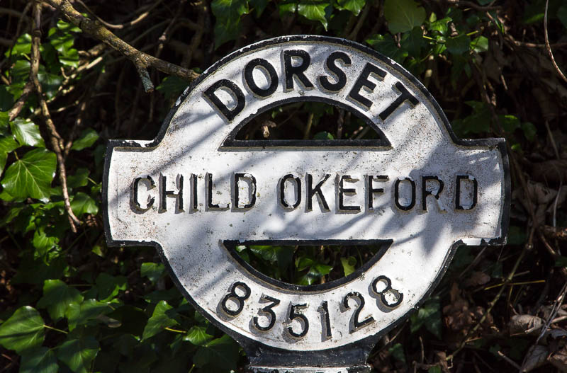
This answer explains the importance and value of maps and compasses. An additional point worth making is that many popular trails will have periodic signs giving location information such as nearest street, postcodes, and, best of all, Ordnance survey grid-references.

Here is an example where the grid-reference is ST835128]: enter image description here (the 'ST' part is not on the sign)). The point of those signs is to enable you to give concise location data in the event of requiring emergency services. So, as you walk along, look out for these signs and either take note of or memorise some of these data (until you get to the next sign).

5

Potentially better than a PLB may be a satellite phone, of course in combination with GPS. Although I'm not sure if coverage is better, with a satellite phone one can talk.

Only Iridium has global coverage, but you can consider cheaper alternatives if they have coverage where you're going. Forget about regular mobile phones: mobile phones only have coverage where many people live or visit. You might have coverage elsewhere, or you might not. Do not rely on regular mobile phones. Some people even leave their mobile phone switched on when in nature, which of course means it will run out of battery (in particular if using GPS, camera, data, tracking apps) and cannot be suitable as an emergency device.

The major advantage of a satellite phone is that you can talk. When you're in a crevasse and lucky enough to still have signal, describing the details of your precise location can save your life ("I fell into the long crevasse with the oddly shaped rock near the lower end"). With poor multipath reception GPS location may be easily be 30 metre off (as opposed to 2–3 metre with good reception), and if emergency services have to explore all crevasses in a 30 metre radius, that is not helpful.

Not knowing where you are can be deadly. Bring a modern handheld GPS device, or be very confident of your navigational skills and constantly follow your position on a high quality topography map.

A good Iridium satellite phone is expensive (well over €1000 for the device), and owning one is uneconomical for most ordinary users. When I go to remote places, I rent a satellite phone. Prices may be in the order of 5–10 €, $, or £ per day, perhaps twice the cost of renting a PLB.

5
  • PLB still wins on reliability in rough terrain. SPoT uses Iridium's network, so a sat phone doesn't have any better coverage than SPoT. If anything a phone is worse off, because simple messaging is easier to connect than a voice call, especially down in a hole where satellites aren't in your sky long. Commented Aug 21, 2019 at 8:42
  • @Harper I'd be curious about evidence of the reliability of PLB vs. SPoT vs. a high-end Iridium satphone. The latter might have a better antenna than SPoT? I don't know.
    – gerrit
    Commented Aug 21, 2019 at 9:06
  • @Harper Spot uses the Globalstar network, so coverage may not be as good as Iridium.
    – vclaw
    Commented Aug 21, 2019 at 17:05
  • Used Iridium sat phones are not that bad, and service for a month isn't horribly expensive compared to the cost of getting to where they might be required such as the high arctic. Commented Aug 23, 2019 at 16:05
  • @SpehroPefhany You don't need to go as remote as the high Arctic to get somewhere where Iridium is required. From western or central Europe one can get to remote enough (to need satphones) areas north of the Arctic Circle for relatively little money. I think rental makes more economic sense for most hikers.
    – gerrit
    Commented Aug 23, 2019 at 16:10
5

If you have a working internet connection (and I realize that it is a big "if"), then chances are that you already have a messaging app installed that can do that: Whatsapp, Telegram, and Facebook Messenger all have an option to send your GPS-determined location to a contact with a couple of clicks.

This is probably obvious for many of you, but I thought it was worth remarking.

2
  • Telegram lets you outright share your live location with any contacts.
    – alamar
    Commented Aug 23, 2019 at 9:06
  • 1
    WhatsApp also has live location sharing, and Google Maps has it during navigation. Those are only useful if you're moving and they eat battery; if stuck, better share fixed location once. Commented Aug 26, 2019 at 10:43
5
+50

The crucial point is directing the emergency personnel correctly. The question seems to be "Where am I?", but indeed the question is "How can they reach to me?" For an useful and relatively short answer, you have to act as the eyes of the emergency personnel and help them to quickly identify your approximate location. You need immediate help; you want help; you are the only person who knows your condition and location, so you have to guide the emergency personnel. You're now a part of the rescue effort. You're now part of the team; welcome.

It's an emergency; so, you don't have time, energy or ability to investigate the area thoroughly and describe it at length. Your talk should be short, clear and informative. I think, the operator on the emergency phone line would try to direct you to get important information from you.

How can they reach to me?

( I responsed to the situation to prevent getting worse.)

1- I have to investigate my situation and surrounding area (even if I can't move). Look around, listen, smell, touch, do whatever I can do.

2- Call emergency number; I have to explain the event, why I need help, what is my health condition and who I am. (I guess, all emergency call centers in the world record the conversations. I think I can talk a little fast.)

3- I have to describe my situation. What should they look for when they get to the area?

I'm stuck between rocks. I'm not visible./I'm in open. I'm lying on dirt.

4- I have to describe my location. They need distinct landmarks and clues to find me. My location has two dimensions.

First one is the physical properties of the area. Buildings, bridges, streams, shape of a hill, type of the trees, color of the rocks; anything that can be used to narrow down the area. More information is always better.

I was climbing to Mount X. I fell. I'm on the mountainside. The sun is hitting my face. (Can be used to guess the elevation and direction.)

Second one is the story that took me to this location. Which town or valley did I pass on the road to here? And when? What was I doing just before the accident?

I was driving to City X. I passed by Y gas station 1 hour ago.

5- If I am able to move, I should stay near the point that I have told and where I could communicate with them by phone. And either I can move or not, I should try to make myself more visible.

1
  • Awarded my bounty to this answer. It specifically addresses additional non-technological solutions.
    – user40521
    Commented Aug 27, 2019 at 19:11
4

If you have a good amount of cash (Cash to burn), for the trip being a planned one and maybe to a remote location, you could splash out and buy yourself a Breitling Emergency watch.

Now these things are not cheap. You are talking $15k +

They come equipped with an authentic dual frequency distress beacon "A marvel of miniaturisation and technical sophistication"

The technology used will launch allerts as well as guides homing and rescue operations.

Direct from wikipedia:

The Breitling Emergency watch contains a radio transmitter for civil aviation use which broadcasts on the 121.5 MHz distress frequency and serves as a backup for ELT-type airborne beacons. For military users, the Emergency has a miniaturized transmitter operating on the 243.0 MHz military aviation emergency frequency. Under normal conditions—flat terrain or calm seas—the signal can be picked up at a range of up to 90 nautical miles (167 km) by search aircraft flying at 20,000 feet (6,000 m).[8] Since 1 February 2009, the Cospas-Sarsat Satellite System has not monitored the 121.5/243.0 MHz frequency; however, the signal transmitted by the Emergency was never strong enough to be picked up by satellite, and Breitling has announced that, as these frequencies will still be monitored by aviation, particularly during the localization phase of a rescue attempt, there are no plans to modify the signal's frequency.

Note though, it comes with a hefty fine if you use this irresponsibly!

3

You can use an old-fashioned flare gun and hope that someone will report it. Whistles and mirrors/lights are also often used in case of emergencies.

More modern option is Spot which uploads your position at least every 60 minutes and allows you to call for help or mark as safe. Because it uses GPS and sends messages through similar frequencies you need to have the sky visible to be able to communicate. As your position is updated periodically someone can monitor your progress and call for help when there is no movement. This will help you in case you are unconscious or stuck in a cave/dense woods and are unable to communicate.

1
  • Actually Imma withdraw my objections because this is one of the edge conditions SPoT might've actually beat 406. Commented Aug 21, 2019 at 0:01
3

If you do have cell service and have an iPhone on you, you can send an Emergency SOS. It will call Emergency Services for you and send your location to your emergency contacts. Your emergency contact will have your location and should be able to provide it to the emergency services, if you are unable to do so (for example when you lose consciousness) or your connection is not reliable enough to provide it over a phone call.

Here's how to make the call on iPhone 8 or later:

  1. Press and hold the side button and one of the Volume buttons until the Emergency SOS slider appears.
  2. Drag the Emergency SOS slider to call emergency services. If you continue to hold down the side button and Volume button, instead of dragging the slider, a countdown begins and an alert sounds. If you hold down the buttons until the countdown ends, your iPhone automatically calls emergency services.

Here's how to make the call on iPhone 7 or earlier:

  1. Rapidly press the side (or top) button five times. The Emergency SOS slider will appear. (In India, you only need to press the button three times, then your iPhone automatically calls emergency services.)
  2. Drag the Emergency SOS slider to call emergency services.

After the call ends, your iPhone sends your Emergency contacts a text message with your current location, unless you choose to cancel. If Location Services is off, it will temporarily turn on. If your location changes, your contacts will get an update, and you'll get a notification about 10 minutes later.

3

If you use an Android phone with Google services enabled (which is the case if you did not put your own firmware) then you can continuously share your location with people you choose. The positioning is not always 100% accurate but for a slow moving person (walking) it should be good enough (I noticed that when biking, some of the points (maybe one or two over 15 km) are off by ~100 m).

Go to Google Maps and choose "position sharing" in the menu (I have the French version so this is a translation).

Make sure to do that before leaving so that your position is recorded all the time and someone can see the "last good" one if you would not have data access when being in danger.

2

I have an app called Life360. It tracks your location using GPS, and at any time you can send a help alert witch notifies emergency contacts by text and email and you can call emergency services. Your last known location can be viewed by selected people at any time. Link to download.

2

From your description, I can guess that any kind of trip is included, including maritime endeavors. In addition to @JonCuster answer, I would also like to add that for maritime distress situations, you have EPIRB.
EPIRB is, in concept, very similar to PLB but with its own set of requirements:

  • Must comply with AS/NZ Standard 4280.1 (EPIRB)
  • Maritime legislation states if vessels traveling more than 2nms from coastline must carry an EPIRB registered with AMSA.
  • CASA (Aviation) legislation states under General Aviation aircraft must have either have an ELT, EPIRB or PLB.
  • Must transmit for a minimum of 48hrs
  • Must float vertically self right
  • Must have a strobe light
  • Must have a lanyard
  • Must have reflective tape
  • Options for methods of activation include; manual switch, manual & water switch
  • Options for bracket include; manual release bracket or float free enclosure

Although primarily designed for Maritime use some people purchase EPIRB to meet maritime legislation and use it for a secondary use for land use or aviation. EPIRBs are bigger and heavier in general.

1

All Samsung phones I had (and this is probably true for many other phones as well, Xiaomi phones being an example of not having this functionality) have an "Urgency Mode" (translated from French).

It is triggered by long-pressing the power button and pressing the relevant icon, or pressing the power button quickly five times.

It automatically sends SMSes to pre-defined contacts with a SOS message and the best available position.

You must log in to answer this question.

Not the answer you're looking for? Browse other questions tagged .