60

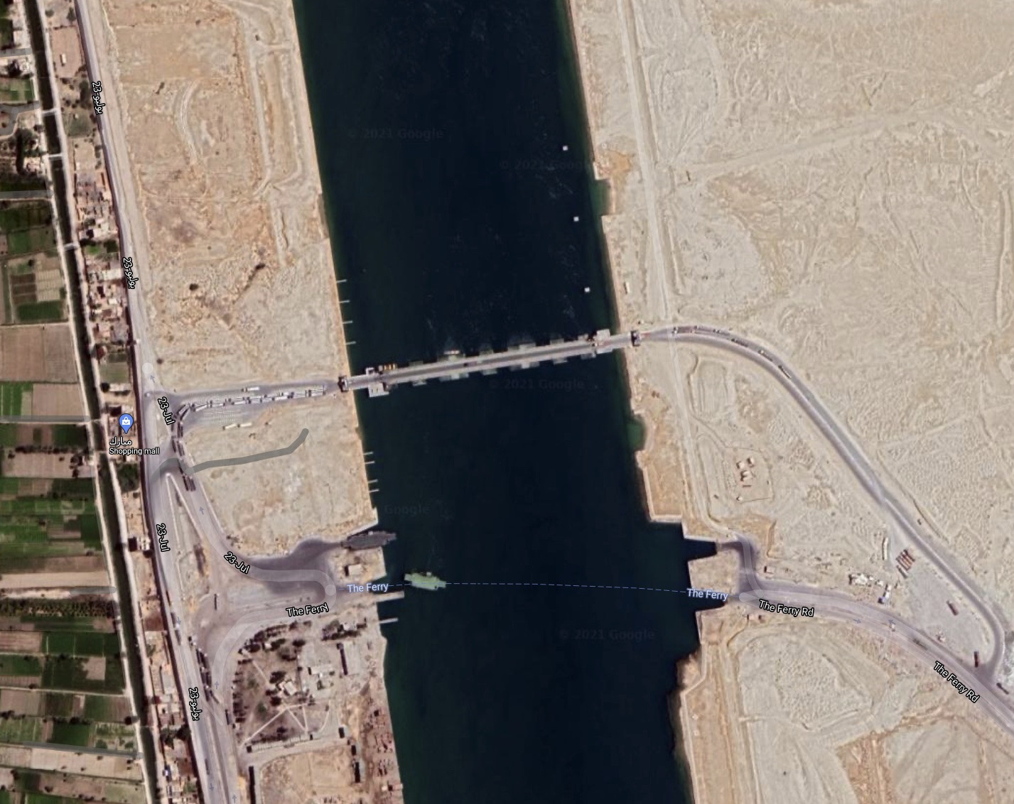
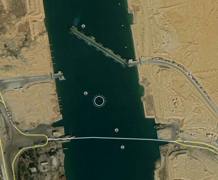
At this location on Google Maps, there appears to be a bridge over the Suez Canal. Wikipedia states that no such bridge exists, and it does not exist on Bing, but in the Google images there is clearly some structure with vehicles both queueing up an driving over it.

picture of canal bridge

What is this? Is there a bridge there?

5
  • 1
    Is it the Martyr Ahmed El-Mansy Floating Bridge? The text says it connects the governorates of Port Said etc... In your map link there is a tag saying "Shopping Center, Fifth Shyakha, Al Ganayen, Suez Governorate, Egypt." Commented Mar 29, 2021 at 19:02
  • 4
    Gutted. When I went from Cairo to Dahab, I was very much looking forward to seeing the Suez, only to go in a tunnel under when we got close :(
    – Mark Mayo
    Commented Mar 30, 2021 at 1:58
  • The link to Bing maps should be this, not what you actually posted, which is to the north of the point in the Google maps link.
    – Ruslan
    Commented Mar 30, 2021 at 20:36
  • 1
    Wikipedia has a list of (permanent) pontoon bridges, which lacks these over the Suez - maybe I'll update it later Commented Mar 31, 2021 at 13:09
  • Wikipedia is updated now.
    – Willeke
    Commented Apr 1, 2021 at 4:37

3 Answers 3

48
+500

There is an entry for it in OpenStreetMap, noted as "movable bridge". The government website for the Canal has a gallery for a "floating bridge", which suggests it is some form of pontoon bridge. Using this lets us dig around a bit and it turns out that there are a number of different pontoon bridges recently established at various points on the canal:

  • The El-Nasr bridge in Port Said (northern end of the canal) was opened in 2016; this article gives some engineering details and a very similar photo. Labelled on Google Maps here, and you can see it being split open to allow through passage of ships (or possibly it is in the middle of being reassembled).

  • The Abanoub Gerges bridge in El Qantara was opened in 2017. Labelled on Google Maps here.

  • The Ahmed el-Mansy bridge was opened in 2017 at Ismailia; this page has a photo of it being traversed by a container ship. Labelled on Google Maps here. The Google Maps image suggests they are fully rotated against the bank, while the photo in the article suggests middle sections can be removed seperately. Could be it's worked both ways.

  • The Taha Zaki Abdullah Bridge in Ismailia was opened in 2019. This is probably on Google Maps here - it's not specifically named, though. You can see a pair of pontoon bridges pulled alongside the edges of the channels, and on the western bank, a series of individual pontoon units.

  • The Ahmed Omar Shabrawy bridge is in Al Shat district in Suez governorate; opening date not clear.

This 2019 statement confirms five bridges were established. I think the last one, Ahmed Omar Shabrawy Bridge, is the one we're seeing here; the others are too far north and can be identified separately on the maps.

3
  • 17
    Since shipping in the canal operates in convoys, there will be long periods (i.e. several hours) with no ships passing a given location - i.e. the time for the end of one convoy to travel X miles in one direction, and the start of the next one to arrive after travelling X miles in the other direction.
    – alephzero
    Commented Mar 30, 2021 at 15:52
  • 1
    @alephzero so they now have Northbound convoys, Southbound convoys, and East-West (not quite) convoys, with the latter being of non-floating traffic. A minor upgrade to the scheduling system in normal times, though I doubt anything is easy round there at the moment. Commented Mar 31, 2021 at 13:06
  • Further reading: en.wikipedia.org/wiki/Suez_Canal#Convoy_sailing
    – 0xFEE1DEAD
    Commented Mar 31, 2021 at 20:10
64

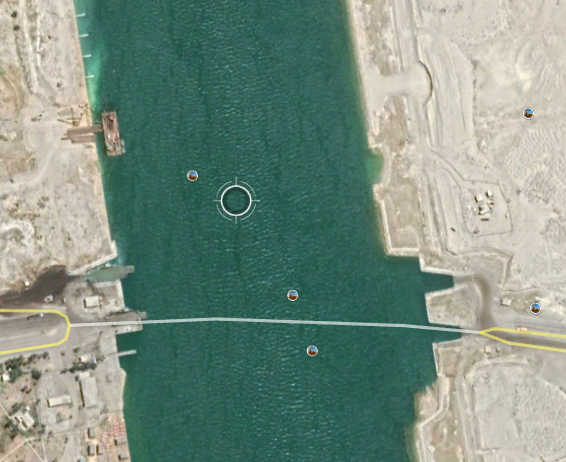
This bridge appears to be a permanent installation. In Google Earth, the first evidence I can see of its construction is June 2018:

enter image description here

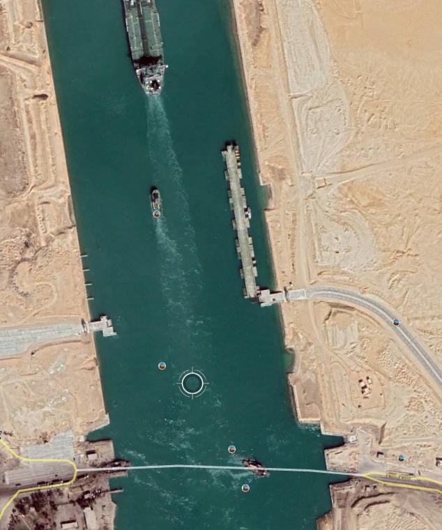
In February 2019, you can see the completed bridge out of the way of ship traffic:

enter image description here

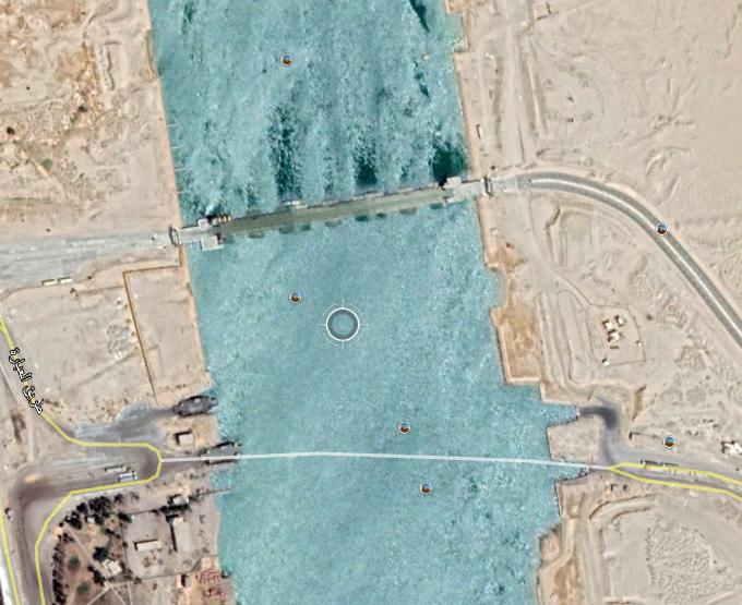
It is first seen closed in August 2019:

enter image description here

November 2019 shows the bridge in action:

enter image description here

1
  • 1
    If it can pivot back and forth quickly enough, the net traffic throughput will far exceed that of the little ferry that seems to have been the previous solution. Just needs good canal traffic forecasting and control (either way - the ferry doesn't want to get run over by giant cargo ships).
    – Jon Custer
    Commented Mar 31, 2021 at 15:55
12

It looks like a pontoon bridge, which is in the water.
Those are often used as a temporary solution and can be taken out without leaving (many) traces when no longer needed.
They are also easier to put in than other kinds of bridges.

As the pontoons are in the water and the road surface only a bit above, it blocks all traffic on the water, so usually there is a part that can be floated away to let shipping go through. But it is not the easiest thing and mostly pontoon bridges are not kept longer than needed.

I bet that you will not find this bridge on photos of an other year, maybe not even from an other month, week or even day.

It may be that the ferry was out of use or that there were other problems which made for a need for a temporary bridge. And seeing the amount of trucks I think that is proven.

In an other answer is mentioned that this is/might be a new connection, meant to be a long term feature.

(Answer edited based on the answer by Andrew.)

0

You must log in to answer this question.

Not the answer you're looking for? Browse other questions tagged .