20

Is there any site that provides city maps adapted to be printed at home to an A4?

I'm traveling to a country where internet access is hard to get and it would be very useful to carry those maps for the 7-8 cities that I will be visiting. For instance, to beforehand mark the places I want to see or where my hotel is.

There are plenty of sites that offer high resolution maps to print as posters, but I need just some simple schema of the city.

Note: I am travelling to Cuba but a general answer is okay.

5

7 Answers 7

21

If you have a phone, you can download the maps (offline maps in Google Maps).

Often you find some tourist information with maps on airports/bus stations/train stations, but it doesn't seem your case. If you are traveling with a car, take a GPS (offline maps) or buy a road guide: much less troubles.

An alternative is to go to a library, and get a guide and you can do copies of the relevant pages. But often they do not have road maps, and the city maps are often confusing (no or bad overview map).

There are also versions to print on OpenStreetMap, but I find them mostly useful for pedestrians, and BTW now I download their maps on my phone (with one of the many apps you can find).

I really recommend you to use a GPS device or offline maps on your phone, so that you can select the scale (e.g. how to enter into a city, and to navigate to the right part, and then to the hotel).

8
  • 3
    Some areas does not permit this. For instance Japan, this is not permitted by copyright and enforced by google maps
    – Simson
    Commented Oct 24, 2019 at 5:57
  • @Simson but you can rent a portable Wi-Fi hotspot for a very reasonable price in Japan. At least reasonable when comparing with all the other prices.
    – Mołot
    Commented Oct 24, 2019 at 10:36
  • 13
    Actually, I'd recommend pre-downloading the maps even when internet access can be counted on: you often have limited bandwidth/data abroad, or it is expensive, so pre-downloading the bulk of them will save both money and time, on top of helping you out of a tight spot should you suddenly find yourself without internet access. Commented Oct 24, 2019 at 14:33
  • 2
    @Simson, that is correct for Google maps, but as this answer states, Openstreetmap does allow for download and does include (at least some parts of) Japan. App-wise, I've used MAPS.ME, which has worked fine in Japan (greater Tokyo area), although I'm sure there are other OSM apps that would also work. Commented Oct 24, 2019 at 18:46
  • 1
    Yet this doesn't talk about printing, which is quite explicit in the question.
    – Mast
    Commented Oct 26, 2019 at 10:09
17

There are various third-party services offering free printable maps based on OpenStreetMap. Many of these services are listed at OSM on Paper. There you can find, among others:

The quality of OSM-based maps varies between different geographic regions but can be quite impressive.

2
  • 1
    The table in the OSM Wiki actually tells you what paper sizes each service supports.
    – csk
    Commented Oct 24, 2019 at 14:46
  • 1
    Having played with both, I rate inkalas much higher than fieldpapers. Better grid/scale, the ability to add your own GPX routes, and a much better idea of how much detail you're going to get before generating the PDF. Fieldpapers also has massive jpg artefacts that obscure fine detail if you don't zoom in further than I'd like (but I'm aiming for 1:100,000 to 1:200,000 with every single road and bike path shown) +1 Commented Oct 26, 2019 at 18:04
8

I use an app called maps.me when I travel.

I can download in advance the data for an area I intend to be in and view it as needed off-line on a tablet or smartphone.

I can also do a screen shot and then print that if I want paper.

The app does navigation when off-line (but sometimes suggests weird unnecessary detours).

It also allows me to send corrections to Open Street Map, but its editor is not very well done.

2
  • I should point out that there are likely other apps that do some or all of this. I put up with the flaws of maps.me because I don’t have sufficient motivation to learn a different UI.
    – WGroleau
    Commented Oct 24, 2019 at 15:14
  • There are various OSM-based apps with offline maps available, both for Android as well as for Apple iOS.
    – scai
    Commented Oct 28, 2019 at 7:55
6

There are many sites that have one or a few very good maps, of the cities these sites are for.
There are a few world wide maps, like Google and Open Street Map, which have a good standard but are not specialized in touristic maps.

In your case I would first look for touristic sites, tourist information -name city- and only next for the maps sites.
Those maps can be made more helpful by showing your hotel, those touristy things you want. Whether it is restaurants, places to get money, museums or whatever, all those you want and non extra. If you want you can print a poster size but frame the cut you want and print the screen. (Sometimes you may want to use the 'print screen' option.)

And when in a hotel, do not hesitate to ask for a local map. In many places they are happy to hand them out, in other places they do not, asking never hurts.

If you arrive in a city and do not (yet) have a map, you can take a photo of a public map with the information you need. (On your phone, your camera or both.)

1
  • I think this is the only answer that actually addresses what the OP wants .. "tourist" schematic maps. Totally different from just "map data maps".
    – Fattie
    Commented Oct 25, 2019 at 17:07
3

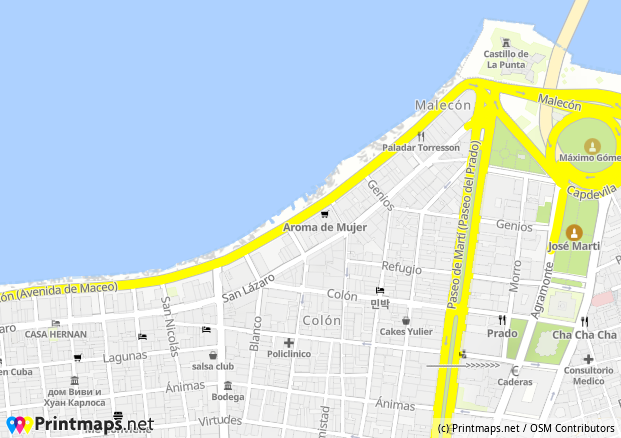
I've used the Printmaps.net editor for a travel photo book, they have highres PNGs (and Illustrator/Photoshop files). Here's a quick map of the Havana Malecón (itchy feet thinking of it):

Havana Malecón map

2

Might not really be what you're looking for since it's not a printed map, but the two times I visited Cuba I used the Android app 'Map Of Cuba Offline'.

It is a very detailed map of the whole of Cuba, it has all the street names I needed, the possibility to save points of interest and what I used often is the GPS-locator when sitting in a taxi. It happened one time I got kinda scammed when taking a cab to Havana Center, and I was dropped of a kilometer outside the old center just because it was easier for the driver. Doesn't happen when you can see where you are with the GPS turned on. (That's also the only one time I got scammed, it's an amazing island I and I will return for sure)

2

A quick search and I stumbled on this:

The PDF is a 50 pages road maps of Cuba; mostly of the roads outside the the main cities.

http://www.cubamappa.com/static/img/carte_guia/pdf_fr/atlas_guia_full.pdf

seems to be an offshoot of a French travel site specializing :

https://www.novelacuba.fr/

0

You must log in to answer this question.

Not the answer you're looking for? Browse other questions tagged .