added 261 characters in body
Source Link
Mark Mayo
  • 159.8k
  • 104
  • 682
  • 1.5k

Oh this is mine.

Firstly, you'll want the flight path. This is available online, provided they stick to it.

Others online suggest the left. This is correct. I'll now explain why.

As you can see from the map, you fly over water a bit, down the coast. The only visible land is to your left. So initially, you definitely want the left.

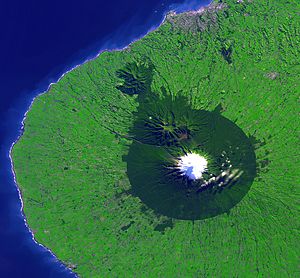
Then you'll cross over part of the Taranaki coast out by New Plymouth. If you're lucky, you'll have a clear view of Mt Taranaki / Egmont.
enter image description here

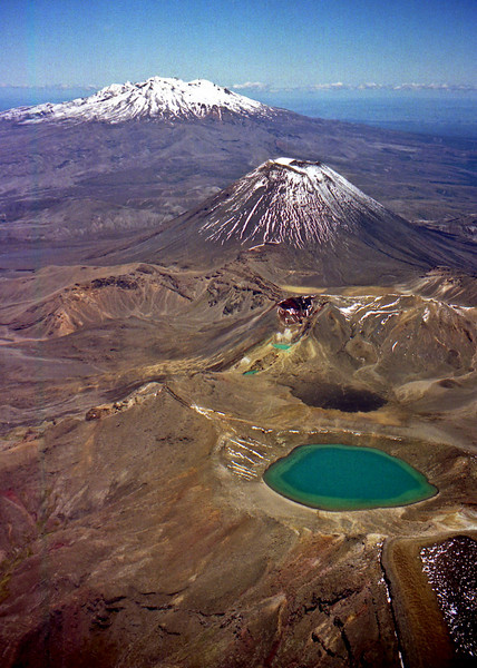
If it passes slightly more inland, to your LEFT again, you may have a view of volcanoes Ruapehu (erupted in 1997) Ngauruhoe and Tongariro. You may recognise Mt Doom from Lord of the Rings ;)
enter image description here

Further south you may get a glimpse of Wellington, before crossing Cook Strait and seeing the beautiful Marlborough Sounds, or if slightly further west - Golden Bay and Farewell Spit.

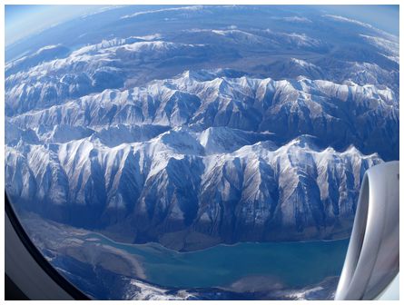
Then the best part starts - the South Island and the imposing Southern Alps. There's some snow at all times of the year, but it doesn't matter when - they're stunning to see and fly over.
enter image description here

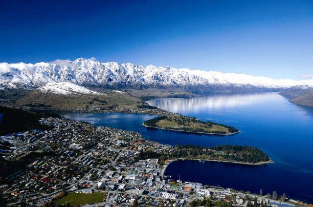
You'll also get to see the amazing lakes - Tekapo, Pukaki, Hawea and Wanaka, and finally Wakatipu - the lake alongside the alpine city of Queenstown. With the Remarkables range in the background, this setting is spectacular, and initially the left side is best, although the plane will then turn in towards the airport.
enter image description here

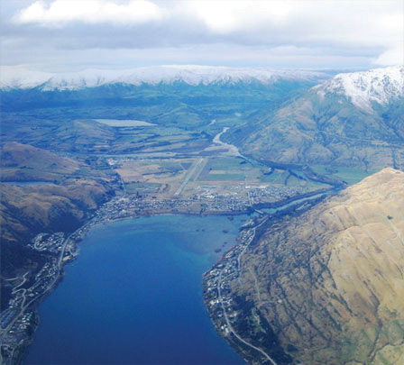
And then you'll have the final approach. One of the most amazing approaches you'll ever do by air - flying between the mountains (with no radar, btw) and down to the little airport, 10 min outside of Queenstown. At this point LEFT or RIGHT is fine - it's spectacular both ways, and the plane usually circles once before going in.
enter image description here

Finally, touchdown! Welcome to Queenstown. Don't forget to Bungy jump ;)

EDIT

And naturally, flying back up to Auckland, you'll want to sit on the right hand side for this scenery. However for the South Island part, either side is spectacular - it's just the North Island that the left pretty much just looks over ocean...

Oh this is mine.

Firstly, you'll want the flight path. This is available online, provided they stick to it.

Others online suggest the left. This is correct. I'll now explain why.

As you can see from the map, you fly over water a bit, down the coast. The only visible land is to your left. So initially, you definitely want the left.

Then you'll cross over part of the Taranaki coast out by New Plymouth. If you're lucky, you'll have a clear view of Mt Taranaki / Egmont.

enter image description here

If it passes slightly more inland, to your LEFT again, you may have a view of volcanoes Ruapehu (erupted in 1997) Ngauruhoe and Tongariro. You may recognise Mt Doom from Lord of the Rings ;)

enter image description here

Further south you may get a glimpse of Wellington, before crossing Cook Strait and seeing the beautiful Marlborough Sounds, or if slightly further west - Golden Bay and Farewell Spit.

Then the best part starts - the South Island and the imposing Southern Alps. There's some snow at all times of the year, but it doesn't matter when - they're stunning to see and fly over.

enter image description here

You'll also get to see the amazing lakes - Tekapo, Pukaki, Hawea and Wanaka, and finally Wakatipu - the lake alongside the alpine city of Queenstown. With the Remarkables range in the background, this setting is spectacular, and initially the left side is best, although the plane will then turn in towards the airport.

enter image description here

And then you'll have the final approach. One of the most amazing approaches you'll ever do by air - flying between the mountains (with no radar, btw) and down to the little airport, 10 min outside of Queenstown. At this point LEFT or RIGHT is fine - it's spectacular both ways, and the plane usually circles once before going in.

enter image description here

Finally, touchdown! Welcome to Queenstown. Don't forget to Bungy jump ;)

EDIT

And naturally, flying back up to Auckland, you'll want to sit on the right hand side for this scenery. However for the South Island part, either side is spectacular - it's just the North Island that the left pretty much just looks over ocean...

added 108 characters in body
Source Link
Mark Mayo
  • 159.8k
  • 104
  • 682
  • 1.5k

Oh this is mine.

Firstly, you'll want the flight path. This is available onlineavailable online, provided they stick to it:.

Others online suggest the left. This is correct. I'll now explain why.

As you can see from the map, you fly over water a bit, down the coast. The only visible land is to your left. So initially, you definitely want the left.

Then you'll cross over part of the Taranaki coast out by New Plymouth. If you're lucky, you'll have a clear view of Mt Taranaki / Egmont.

enter image description here

If it passes slightly more inland, to your LEFT again, you may have a view of volcanoes Ruapehu (erupted in 1997) Ngauruhoe and Tongariro. You may recognise Mt Doom from Lord of the Rings ;)

enter image description here

Further south you may get a glimpse of Wellington, before crossing Cook Strait and seeing the beautiful Marlborough Sounds, or if slightly further west - Golden Bay and Farewell Spit.

Then the best part starts - the South Island and the imposing Southern Alps. There's some snow at all times of the year, but it doesn't matter when - they're stunning to see and fly over.

enter image description here

You'll also get to see the amazing lakes - Tekapo, Pukaki, Hawea and Wanaka, and finally Wakatipu - the lake alongside the alpine city of Queenstown. With the Remarkables range in the background, this setting is spectacular, and initially the left side is best, although the plane will then turn in towards the airport.

enter image description here

And then you'll have the final approach. One of the most amazing approaches you'll ever do by air - flying between the mountains (with no radar, btw) and down to the little airport, 10 min outside of Queenstown. At this point LEFT or RIGHT is fine - it's spectacular both ways, and the plane usually circles once before going in.

enter image description here

Finally, touchdown! Welcome to Queenstown. Don't forget to Bungy jump ;)

Oh this is mine.

Firstly, you'll want the flight path. This is available online, provided they stick to it:

Others online suggest the left. This is correct. I'll now explain why.

As you can see from the map, you fly over water a bit, down the coast. The only visible land is to your left. So initially, you definitely want the left.

Then you'll cross over part of the Taranaki coast out by New Plymouth. If you're lucky, you'll have a clear view of Mt Taranaki / Egmont.

enter image description here

If it passes slightly more inland, to your LEFT again, you may have a view of volcanoes Ruapehu (erupted in 1997) Ngauruhoe and Tongariro. You may recognise Mt Doom from Lord of the Rings ;)

enter image description here

Further south you may get a glimpse of Wellington, before crossing Cook Strait and seeing the beautiful Marlborough Sounds, or if slightly further west - Golden Bay and Farewell Spit.

Then the best part starts - the South Island and the imposing Southern Alps. There's some snow at all times of the year, but it doesn't matter when - they're stunning to see and fly over.

enter image description here

You'll also get to see the amazing lakes - Tekapo, Pukaki, Hawea and Wanaka, and finally Wakatipu - the lake alongside the alpine city of Queenstown. With the Remarkables range in the background, this setting is spectacular, and initially the left side is best, although the plane will then turn in towards the airport.

enter image description here

And then you'll have the final approach. One of the most amazing approaches you'll ever do by air - flying between the mountains (with no radar, btw) and down to the little airport, 10 min outside of Queenstown. At this point LEFT or RIGHT is fine - it's spectacular both ways, and the plane usually circles once before going in.

enter image description here

Finally, touchdown! Welcome to Queenstown. Don't forget to Bungy jump ;)

Oh this is mine.

Firstly, you'll want the flight path. This is available online, provided they stick to it.

Others online suggest the left. This is correct. I'll now explain why.

As you can see from the map, you fly over water a bit, down the coast. The only visible land is to your left. So initially, you definitely want the left.

Then you'll cross over part of the Taranaki coast out by New Plymouth. If you're lucky, you'll have a clear view of Mt Taranaki / Egmont.

enter image description here

If it passes slightly more inland, to your LEFT again, you may have a view of volcanoes Ruapehu (erupted in 1997) Ngauruhoe and Tongariro. You may recognise Mt Doom from Lord of the Rings ;)

enter image description here

Further south you may get a glimpse of Wellington, before crossing Cook Strait and seeing the beautiful Marlborough Sounds, or if slightly further west - Golden Bay and Farewell Spit.

Then the best part starts - the South Island and the imposing Southern Alps. There's some snow at all times of the year, but it doesn't matter when - they're stunning to see and fly over.

enter image description here

You'll also get to see the amazing lakes - Tekapo, Pukaki, Hawea and Wanaka, and finally Wakatipu - the lake alongside the alpine city of Queenstown. With the Remarkables range in the background, this setting is spectacular, and initially the left side is best, although the plane will then turn in towards the airport.

enter image description here

And then you'll have the final approach. One of the most amazing approaches you'll ever do by air - flying between the mountains (with no radar, btw) and down to the little airport, 10 min outside of Queenstown. At this point LEFT or RIGHT is fine - it's spectacular both ways, and the plane usually circles once before going in.

enter image description here

Finally, touchdown! Welcome to Queenstown. Don't forget to Bungy jump ;)

Source Link
Mark Mayo
  • 159.8k
  • 104
  • 682
  • 1.5k

Oh this is mine.

Firstly, you'll want the flight path. This is available online, provided they stick to it:

Others online suggest the left. This is correct. I'll now explain why.

As you can see from the map, you fly over water a bit, down the coast. The only visible land is to your left. So initially, you definitely want the left.

Then you'll cross over part of the Taranaki coast out by New Plymouth. If you're lucky, you'll have a clear view of Mt Taranaki / Egmont.

enter image description here

If it passes slightly more inland, to your LEFT again, you may have a view of volcanoes Ruapehu (erupted in 1997) Ngauruhoe and Tongariro. You may recognise Mt Doom from Lord of the Rings ;)

enter image description here

Further south you may get a glimpse of Wellington, before crossing Cook Strait and seeing the beautiful Marlborough Sounds, or if slightly further west - Golden Bay and Farewell Spit.

Then the best part starts - the South Island and the imposing Southern Alps. There's some snow at all times of the year, but it doesn't matter when - they're stunning to see and fly over.

enter image description here

You'll also get to see the amazing lakes - Tekapo, Pukaki, Hawea and Wanaka, and finally Wakatipu - the lake alongside the alpine city of Queenstown. With the Remarkables range in the background, this setting is spectacular, and initially the left side is best, although the plane will then turn in towards the airport.

enter image description here

And then you'll have the final approach. One of the most amazing approaches you'll ever do by air - flying between the mountains (with no radar, btw) and down to the little airport, 10 min outside of Queenstown. At this point LEFT or RIGHT is fine - it's spectacular both ways, and the plane usually circles once before going in.

enter image description here

Finally, touchdown! Welcome to Queenstown. Don't forget to Bungy jump ;)